YOUR NEXT TRAVEL EXPERIENCE
Search Results
246 items found for ""
- DON'T GET STUCK IN SPIDER WEBS, LAKE ARGYLE ISLANDS OF WESTERN AUSTRALIA
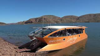
small birds occasionally get trapped in the webs -Tour guide Lake Argyle of Western Australia Is Western Australia's largest freshwater man-made reservoir. Lake Argyle is part of the Ord River Irrigation Scheme and is seventy km by road from the East Kimberley town of Kununurra. One sealed road in and over the one and only bridge. The bridge is of a modern sturdy construction. On occasion in the wet season the bridge has raised concern of extreme monsoonal weather having the capacity of washing the bridge away. Spiders of Lake Argyle Golden Orb Spiders, a familiar sight on the islands dotting Lake Argyle, are known for their intricate webs that span across the gaps between bare branches of the island's small trees. These massive webs, often densely layered, can sometimes ensnare unsuspecting small birds that find themselves entangled in the sticky threads. Navigating through these intricate and tangled webs can be quite challenging, as they are predominantly crafted by the skilled Orb Spiders that call these islands home. One interesting fact about Orb Spiders is that their bites, while generally not dangerous to humans, can cause mild local pain, numbness, and swelling. Despite their potentially discomforting bite, these spiders play a crucial role in the ecosystem of Lake Argyle, helping to control insect populations and maintain the delicate balance of the island's biodiversity. The presence of these spiders adds a fascinating layer to the natural tapestry of the islands, showcasing the intricate interplay between different species in this unique environment. Freshwater crocodiles Numbers are estimated at over 25,000 in the lake. No saltwater crocodiles are said to be found. They much prefer mangrove habitat. However a one hundred per cent guarantee is not assured. The lake has twenty-six species of native fish. Fish species known in Lake Argyle include; Barramundi Southern Saratoga Archer Fish Forktail Cat Fish Mouth Almighty (is an actual fish) Long Tom Bony Bream Sleepy Cod These fish species known to inhabit Lake Argyle are a fascinating mix of freshwater creatures that have adapted to the unique ecosystem of this reservoir. The Barramundi, a prized sportfish, is a common sight in these waters, known for its impressive size and fighting spirit. The Southern Saratoga, with its vibrant colors and distinctive fins, adds a splash of beauty to the lake. Archer Fish, famous for their ability to shoot down insects with water jets, showcase an interesting hunting behavior. Among the lesser-known species, the Forktail Catfish lurks in the depths, its whiskers sensing the environment for food. The Mouth Almighty, an actual fish with a quirky name, captures attention with its peculiar features and behavior. Long Toms, with their elongated bodies and sharp teeth, are efficient predators in these waters. Bony Bream, a staple food source for many other fish, play a crucial role in the lake's food chain. Lastly, the Sleepy Cod, a nocturnal species, brings a sense of mystery to Lake Argyle with its secretive habits and elusive nature. These diverse fish species collectively contribute to the rich biodiversity of Lake Argyle, making it a prime destination for anglers, researchers, and nature enthusiasts alike. Traveldriven ENTER CLICK/TAP LAKE ARGYLE GOOGLE MAPS IN REALTIME DRIVE KUNUNURRA TO LAKE ARGYLE Lake Argyle random island stop & giant spider webs VERY COLD POOL AND LAKE ARGYLE The one bridge crossing on the sealed road to Lake Argyle One of the very few boats on Lake Argyle LAKE ARGYLE BOAT CRUISE & BBQ PREV SA/WA/NT NEXT PREV WEST AUSTRALIA NEXT HOMEPAGE
- TIME OUT WITH FUNNY DRIVING GIF'S CLICK/TAP
Driving Gif's Funny driving Gif's for a good laugh. How, when and where not to drive. Who should not drive. Mad, bad, terrible, see it to believe it driving. Twenty-five funny gifs. Allow for a short loading time. Which one are you! The first Gif is titled Dog Gone Driving. How many cars are seen with dogs in the front looking out of the side window. Quite a few are seen on rural roads. Some are on the driver's lap while driving. Traveldriven DOG GONE DRIVING.. Two Wheel Driving I have never seen the front wheels of a car lift off of the ground from a standing start unless it's at a drag strip. There's a first time for anything though. Twisted Driving Stunt drivers jump cars and motorcycles off ramps over all manner of things. Don't think it's possible to twist a vehicle 360 degrees in mid air without video editing. Stop Driving Some drivers become over hyped. Perhaps from fatigue of no rest breaks. Instead of nodding off they just fidget around to stay awake. Hitchhiker driver Rare to see a hitchhiker now. I have never seen a solo female hitchhiker. Wide Eyed Driving A few drivers appear to drive with no idea. Don't pay attention to where they are or going. Flying Driving Happens occasionally. Not driving to suit the poor road conditions and skip over pot holes, gutters and kerbs. Fancy Driving As stated before. Never seen a woman, let alone dressed in nice clothes, hitchhiking. Dummy Driver Unfortunately there are quite a few dumb drivers. These drivers don't allow for braking. Filling gaps, constant lane changing, not altering to the correct posted speed, inattention etc. Revved Up Driving Who hasn't seen the driver revving their car engine stopped at traffic lights. Driving Blind Not as in drunk. Vision is impaired by fog, misted windows or poor eyesight. Takeaway Driving A driver's passenger momentarily holds the wheel while the driver reaches for something. Seen this more than once. Pretty shocking. Cross Country Driving Not only in 4wd but 2wd also. Across paddocks and between roads. Does wonders for bottoming out the underside of the car. Please Stop Driving We all know these drivers. Scary to passengers by careless or dangerous driving practices. Boosted Driving Cars do tip over. Sometimes onto the roof. Swerving on the road hazards. Driving on very uneven terrain. Rough tracks. Driving Hunger Who hasn't been driving and can't find a wayside stop to eat at or driven past a roadside eatery and can't turn around to go back. Just Drive Sometimes you just can't get going. Vehicle won't start or waiting on passengers. Too Much Driving can drive you loopy. Usually no rest breaks or stuck in very heavy traffic. Can't Drive Driving impairment for some reason. Medical, physical, psychological reasons. Stopped Driving Stranded beside the road for mechanical reasons. Out of fuel. Redneck Driving Ignoring the road rules and other road users. Dangerous to all including themselves. Keep Driving taking much longer than expected to get to the final stop. Continue driving until it's reached. Driving Racecraft Usually imagining how you should drive verses how you do drive. Driving with Armstrong Steering Many early model cars and large vehicles are hard to manoeuvre with excessive steering wheel movement lock to lock. Driving Wild There can be plenty of distractions while driving HOMEPAGE
- POLICE WAVE FORD MUSTANG GT DRIVING THROUGH CHECKPOINT
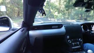
Roadside Checkpoint Victorian law enforcement conducted a random roadside checkpoint to inspect vehicles for roadworthiness and verify licenses and registrations. During this operation, the police granted permission to proceed without interruption through the checkpoint driving a Ford Mustang GT after confirming compliance with all requirements. ROADWORTHY VEHICLE CHECKS wheels and tyres. steering, suspensions and braking systems. seats and seatbelts. lights and reflectors. windscreen, and windows including front wipers and washers. vehicle structure. other safety related items on the body, chassis or engine. According to VicRoads, approximately 48,000 defect notices or 'canaries' for unroadworthy vehicles are processed each year throughout Victoria. The Road Safety Act 1986, a pivotal legislative framework in Victoria, plays a crucial role in ensuring the safety and compliance of vehicles on the roads. This act empowers police officers and authorized personnel to take necessary actions when encountering vehicles that do not meet the stipulated safety standards. The issuance of defect notices, commonly referred to as 'canaries,' serves as a vital mechanism to address the issue of unroadworthy vehicles within the state. These defect notices act as a warning to vehicle owners, prompting them to rectify any identified issues promptly. By processing approximately 48,000 defect notices annually, VicRoads aims to uphold road safety standards and reduce the risks associated with driving vehicles that do not comply with regulations. Through the diligent enforcement of the Road Safety Act 1986, authorities strive to create a safer environment for all road users in Victoria. This proactive approach not only enhances public safety but also underscores the importance of vehicle maintenance and compliance with established regulations to prevent accidents and promote responsible driving habits. The Road Safety Act 1986 provides that a police officer or authorised person may, in accordance with the regulations, on discovering a vehicle that does not comply with this Act or the regulations may: 1 issue a warning or a vehicle defect notice, or 2 impose conditions on the use of the vehicle, or 3 prohibit the use of the vehicle POLICE WAVE MUSTANG GT DRIVING THROUGH CHECKPOINT RANDOM POLICE BREATH TEST FOR .05 VICTORIAN TESTING BUS PREV VICTORIA NEXT HOMEPAGE
- HOBART & CRAZY ARTWORK MONA TASMANIA
MONA TASMANIA Museum of Old and New Art. Visited February 2018 The Museum of Old and New Art (MONA) is an art museum within the Moorilla winery in Hobart, Tasmania. Apparently it's the largest privately funded museum in the Southern Hemisphere. MONA houses old and modern art collected by David Walsh founder of MONA. Themes of sex and death. The museum is described by Walsh as a "subversive adult Disneyland". MONA was officially opened on 21 January 2011. MONA also hosts arts festivals which showcase public art and live performances. Saturday morning is the famous Salamanca Market day in Hobart's CBD. Great to wander around and look at the market stalls. I received a parking ticket on my car. Which I paid. Held since 1945 and starting on Boxing Day in Sydney. The Sydney to Hobart yacht race distance is approximately 630 nautical miles (1,170 km). Yacht crews celebrate on New Year’s Eve at Constitution Dock in Hobart. Traveldriven GOOGLE MAPS ENTER CLICK/TAP HOBART https://www.google.com/maps/place/Hobart+TAS ENTER CLICK/TAP MONA https://www.google.com/maps/place/MONA HOBART FIVE DAY WEATHER FORECAST DRIVE FROM HOBART TO MONA TASMANIA WEIRD CAR DESIGNS JUMP ON MY BONES MONA ART MONA WRITING ON THE WALL PREV PAGE NEXT HOMEPAGE
- LAUNCESTON & FREE DINNER, CAR DISPLAYS & CHAIRLIFTS
out to dinner at a local hotel and received a free meal, thankyou Launceston is a northern city in Tasmania. Located where the North Esk and South Esk rivers meet and become the Tamar River. With a population approaching ninety thousand residents, Launceston is the second most populous city in Tasmania after Hobart. Accommodation was in Launceston. Cataract Gorge is close by and a popular tourist area. Many bushland walks are near the gorge. Tourists may ride the chairlift stretching over 300 metres across the gorge. With drizzling rain in the carpark a young boy stopped next to the mustang GT with his dad and snapped a photo of them and the car. I went out to dinner at a local hotel and received a free meal. I asked why? The chef said he saw the mustang GT parked out the front. The car is his favourite. I offered to pay and thanked him. No, the meal is on me. Thankyou. Traveldriven ENTER CLICK/TAP LAUNCESTON GOOGLE MAPS NATIONAL AUTOMOBILE MUSEUM GOOGLE MAPS LAUNCESTON FIVE DAY FORECAST EARLY MODEL MUSTANG 1966 SHELBY MUSTANG GT 350 1970s CAR CAMPINGPEN TOP CRUISING 1932 AUBURN AUBURN 852 CATARACT GORGE LAUNCESTON PENNY ROYAL FLYING FOX PREV PAGE NEXT HOMEPAGE
- THREE SISTERS IN THE BLUE MOUNTAINS, TRAVEL DOWN UNDER
Under a two hour drive from Sydney. Visit for a weekend. The Three Sisters are three spectacular pillars of sandstone rock in the Blue Mountains of New South Wales, Australia. They are located close by to the town of Katoomba. They rise above the Jamison Valley. Names are Meehni (922 m), Wimlah (918 m), and Gunnedoo (906 m). There are plenty of scenic views where the Blue Mountains appear blue across the valley. Under a two hour drive from Sydney. Travel Down Under Within walking distance, guests can enjoy a delightful culinary experience at the nearby Echo Point Plaza, where they can savor a variety of delicious dishes for lunch and indulge in a freshly brewed cup of coffee. Additionally, visitors can explore the thrilling attractions of the area, such as the Scenic Skyway and Cliffhanger railway, both of which are conveniently located just a short walk away. Scenic Skyway. The Scenic Skyway offers a unique adventure as it takes passengers 720 meters above the breathtaking Jamison Valley, providing unparalleled panoramic views of the surrounding landscape. This fully enclosed gondola cabin ensures a safe and comfortable journey across the valley, allowing travellers to witness the beauty of the area from a bird's eye perspective. With its horizontal trajectory and spacious capacity, the Scenic Skyway promises an unforgettable experience for all who embark on this remarkable ride. Cliffhanger. Known as the world's steepest passenger railway, the Cliffhanger Scenic Railway is an adrenaline-pumping attraction that follows a daring 310-metre route along the cliffside. Featuring adjustable seating that can incline up to a thrilling 64 degrees, this railway offers a vertical ascent up the cliff face, providing a heart-pounding experience for adventure enthusiasts. While the Cliffhanger Railway offers a one-of-a-kind journey, it may not be suitable for those who are uncomfortable with heights, as the dramatic incline adds an extra level of excitement to this exhilarating ride. Traveldriven ENTER CLICK/TAP THE THREE SISTERS GOOGLE MAPS IN REALTIME TRAVEL DOWN UNDER DRIVE SYDNEY TO THE THREE SISTERS PREV NSW NEXT PREV AUSTRALIA ICONS NEXT HOMEPAGE
- WALK MAGNETIC ISLAND FORTS OF THE GREAT BARRIER REEF
Magnetic Island of the Great Barrier Reef The island is eight kilometres (5.0 mi) offshore from the city of Townsville, Queensland. Quite mountainous in places. Regarded by many local people as a suburb of Townsville, with greater than two thousand permanent residents many commuting daily to Townsville by ferry. Magnetic Island by passenger & car ferry from Townsville takes approximately 25 minutes. Magnetic Island is locally known as ‘Maggie’. Jet Ski Tour Around Magnetic Island A day trip to this stunning island offers a perfect opportunity to immerse yourself in its natural beauty and rich history. You can embark on a thrilling three-hour jet ski tour around the island, where you might be lucky enough to spot turtles and other fascinating marine life. For history enthusiasts, exploring the Magnetic Battery World War 2 ruins, also known as 'The Forts,' along the Forts Walk is a must-do activity. This free-to-explore site provides a glimpse into the island's past and adds a unique dimension to your visit. Additionally, nature lovers can indulge in a leisurely four-kilometre easy walking track that winds through the island's hilly terrain, adorned with large granite boulders, majestic pines, and pristine sandy beaches. The island boasts a variety of accommodation options to suit every preference, ensuring a comfortable stay for all visitors. It's worth noting that over half of the island is designated as a national park, making it a haven for biodiversity and a part of the southern Great Barrier Reef ecosystem. This status not only preserves the island's natural wonders but also offers visitors a chance to connect with and appreciate the unique flora and fauna that call this island home. Traveldriven ENTER CLICK/TAP MAGNETIC ISLAND GOOGLE MAPS PREV BARRIER REEF NEXT PREV QUEENSLAND NEXT HOMEPAGE
- DAYDREAM ISLAND NAKED MERMAIDS THE GREAT BARRIER REEF
Daydream Island One of many islands within the Whitsunday Islands group in Queensland, Australia. A part of the Great Barrier Reef. Daydream Island is small in size. One km in length and 400m at its widest. The highest point, fifty-one metres above sea level. Daydream Island is in the Whitsundays Island group 5km off the Queensland mainland. An easy 30 minute ferry transfer from Hamilton Island where daily interstate flights arrive. Much smaller and laid back than the highrise of Hamilton Island. All walking tracks and sights can be done within an easy one hour stroll. Naked Mermaids of the Great Barrier Reef Three life-size mermaid statues named Serenity, Aphrodesia, and Infinity, symbolizing mind, body, and spirit respectively, once graced the main foreshore of the island resort. These stunning sculptures were a beloved feature, captivating visitors with their beauty and significance. Serenity exuded a sense of calm and tranquility, while Aphrodesia represented love and passion, and Infinity embodied the eternal connection between the physical and spiritual realms. However, the devastating Cyclone Debbie in 2017 wrought havoc on the island, washing away these iconic statues along with the memories they held. Despite the passage of time, the absence of Serenity, Aphrodesia, and Infinity is keenly felt by both locals and tourists alike. Their disappearance left a void in the landscape, a reminder of the destructive power of nature. In the aftermath of Cyclone Debbie, the island resort underwent a complete renovation to restore its former glory. While the physical damage caused by the cyclone has been repaired, the emotional and symbolic loss of the mermaid statues lingers on. The decision not to replace them speaks to the island's resilience and ability to adapt to change, yet their absence serves as a poignant reminder of the impermanence of beauty and the cycle of creation and destruction that defines the natural world. The island resort has been fully renovated after cyclone Debbie. Updated accommodation and attractions. A new replacement Outdoor Cinema. A new underwater observatory A new expanded Living Reef experience lagoon with more than 100 species of marine fish rays etc. spreads 200m through the resort. Kayak's are available for hire. Kayak around the island. Traveldriven ENTER CLICK/TAP DAYDREAM ISLAND GOOGLE MAPS IN REALTIME DAYDREAM ISLAND MERMAIDS LOST AT SEA Daydream Island Mermaids PREV BARRIER REEF NEXT PREV QUEENSLAND NEXT HOMEPAGE
- BONDI BEACH CURRENT TEMPERATURE & FIVE DAY WEATHER
Bondi Beach Bondi Beach is a famous beach and takes it's name from the surrounding suburb in Sydney, New South Wales. Bondi Beach is about seven km (4 mi) east of Sydney central business district and can be easily visited on public transport. Bondi Beach is one of the most visited tourist sites in Australia throughout twelve months of the year. Bondi Beach, located in Sydney, New South Wales, is a world-renowned destination that attracts visitors from all corners of the globe. Its iconic crescent shape, golden sands, and crystal-clear waters make it a must-visit spot for tourists seeking sun, surf, and relaxation. The beach is not only popular during the summer months but also sees a steady stream of visitors throughout the entire year. Aside from its natural beauty, Bondi Beach offers a vibrant atmosphere with a bustling promenade lined with trendy cafes, surf shops, and art galleries. Visitors can soak up the sun, swim in the ocean, or try their hand at surfing in the famous waves of Bondi. The beach also hosts various events and festivals, adding to its allure and making it a hub of activity and entertainment. Moreover, Bondi Beach is not just a tourist hotspot but also a cultural melting pot, attracting people from diverse backgrounds and nationalities. This diversity adds to the unique charm of the beach, creating a welcoming and inclusive environment for all who visit. Travel Down Under To Bondi Beach Circular Quay waterfront Sydney CBD is the departure point to Bondi Beach and is under 10km and approximately 25 minutes travel on the Watsons Bay ferry. Alternatively take a 40 minute bus trip. City2surf This is a 14 kilometre fun run course from Hyde Park, Sydney to Bondi Beach via Kings Cross. Usually held once a year in August. As a spectacle with 80,000 participants running and walking past, the event truly becomes a vibrant display of human spirit and determination. The sheer number of individuals coming together to challenge themselves physically and mentally creates an electrifying atmosphere filled with energy and excitement. Amidst the sea of participants, the novelty entrants stand out with their unique costumes and creative approaches to the race. These individuals not only bring a sense of humor and lightheartedness to the event but also showcase the diverse personalities and interests within the running community. Their presence adds an element of fun and entertainment, captivating the onlookers and fellow participants alike. Each novelty entrant tells a story through their attire and demeanor, turning the event into a colorful tapestry of individuality and creativity. Their presence serves as a reminder that running is not just about competition but also about joy, camaraderie, and self-expression. The sight of these amusing novelty entrants further enriches the overall experience, leaving a lasting impression on all those fortunate enough to witness this extraordinary display of human ingenuity and passion. Traveldriven ENTER CLICK/TAP BONDI BEACH GOOGLE MAPS IN REALTIME CIRCULAR QUAY GOOGLE MAPS IN REALTIME CURRENT BONDI BEACH FIVE DAY FORECAST SYDNEY CBD TO BONDI BEACH GOOGLE MAPS BONDI IN WINTER CITY 2 SURF FUN RUN PREV NSW NEXT PREV AUSTRALIA ICONS NEXT HOMEPAGE
- WHITEHAVEN BEACH SQUEAKY SAND, THE GREAT BARRIER REEF
Whitehaven Beach Whitehaven Beach is a renowned seven-kilometre stretch of pristine white sand located on Whitsunday Island in Queensland, Australia. This iconic beach is a picturesque paradise that attracts visitors from around the world. Accessible by boat, seaplane, and helicopter from Airlie Beach, as well as tourist boats from Hamilton Island, Whitehaven Beach offers a unique and unforgettable experience for all who venture there. The dazzling white sand of Whitehaven Beach is composed of pure silica, giving it a stunningly bright and powdery appearance that is unlike any other beach in the world. The crystal-clear turquoise waters that lap against the shore create a mesmerizing contrast against the brilliant white sand, making it a photographer's dream and a haven for beach lovers. One of the most striking features of Whitehaven Beach is its proximity to the Great Barrier Reef, the world's largest coral reef system. The beach offers a perfect vantage point to admire the natural beauty of the reef, with its vibrant marine life and colorful coral formations. Snorkeling and diving opportunities abound, allowing visitors to explore the underwater wonders of this UNESCO World Heritage Site. Whether you choose to relax on the soft sand, swim in the azure waters, or take in the breathtaking views from above, Whitehaven Beach is a must-visit destination for anyone seeking a slice of paradise in the heart of the Australian tropics. GETTING TO WHITEHAVEN BEACH GREAT BARRIER REEF A thirty minute ride by commercial high speed catamaran from Hamilton Island. Half or full day tours available. Spend an hour or two relaxing on the beach under the supplied popup shades or swim. Watch a seaplane land. Brilliant white silica sand. Sand is very squeaky underfoot. Pre booked overnight national park campsites are available. Very basic amenities. One of two most famous Australian beaches. Both Whitehaven Beach and Bondi Beach. Traveldriven ENTER CLICK/TAP WHITEHAVEN BEACH GOOGLE MAPS IN REALTIME PREV AUSTRALIA ICONS NEXT PREV BARRIER REEF NEXT PREV QUEENSLAND NEXT HOMEPAGE
- DRIVING BACKROADS & HAUNTED BLACKWOOD
Blackwood Is a small town in Victoria surrounded by the Wombat State forest. Population of just a few hundred and experiences cold and wet winters. There is a small mineral springs area behind the town centre. Even locals are heard to complain about the cold winter weather. The town has a few small retail and coffee shops, a small post office and a hotel. Most are only open on selected week days or the weekend. Spirits At The Pub A captivating event that combines paranormal investigation with a delicious dinner experience. This unique gathering takes place once a month at the renowned Blackwood Hotel, a historic venue known for its mysterious past and eerie ambiance. Participants have the opportunity to explore the hidden corners of the hotel, seeking out signs of supernatural activity and communicating with spirits from another realm. During the investigation, guests are equipped with detecting apparel and guided through various areas of the hotel, including secluded corners where paranormal phenomena are said to occur. Experienced investigators share their knowledge and techniques, providing insights into the world of ghost hunting and the tools used to detect otherworldly presences. After the thrilling investigation, attendees can unwind and share their experiences. The cozy atmosphere of the pub adds to the mystique of the evening, creating a perfect setting for recounting chilling encounters and discussing the mysteries of the spirit world. Spirits At The Pub is not just an event; it's an immersive journey into the unknown, where guests can connect with the supernatural and explore the boundaries between the living and the dead. Whether you're a skeptic or a believer, this experience is sure to leave you intrigued and perhaps even questioning the reality of the unseen forces that linger within the walls of the Blackwood Hotel. Bacchus Marsh Is a city located just off of the Western Freeway in Victoria. About fifty kilometres west of Melbourne. Population greater than twenty thousand. Traveldriven ENTER CLICK/TAP BLACKWOOD GOOGLE MAPS BACCHUS MARSH GOOGLE MAPS DRIVE BALLAN-BLACKWOOD-TRENTHAM-GISBORNE-BACCHUS MARSH FOREST DRIVE Driving a two hour loop through the forest. Ballan. Blackwood. Trentham. Gisborne. Bacchus Marsh. DRIVING BLACKWOOD TO TRENTHAM BLACKWOOD HOTEL 'RESURRECTION' est. 1868 Spirits At The Pub. Paranormal Investigation & Dinner Held once monthly. Inside the Blackwood Hotel STEAK SANDWICH, BLACKWOOD HOTEL MAIN BAR BLACKWOOD HOTEL, 'RESURRECTION' DRIVING BACCHUS MARSH PREV VICTORIA NEXT HOMEPAGE
- NO BULL TO DRIVE THE WIMMERA MALLEE
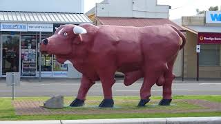
Birchip and Bull in the Wimmera Mallee Birchip is a town in the Mallee. The Sunraysia Highway passes through town and the town is north of Donald. A population of less than one thousand people. The region has gained widespread recognition for its association with the iconic Mallee bull and the rugged Mallee stump. One of the distinctive attractions in Birchip is a meticulously crafted replica of a massive Mallee Bull positioned prominently in the central median of the main street. This artistic representation serves as a testament to the area's rich agricultural heritage and pays homage to the resilience and strength embodied by these magnificent creatures. The presence of this symbolic sculpture not only adds character to the town but also offers visitors a unique opportunity to witness a Mallee Bull up close, showcasing the intricate details and sheer grandeur of this remarkable species. It stands as a striking reminder of the deep-rooted connection between the local community and the land, highlighting the significance of agriculture in shaping the identity of the region. As visitors stroll along the main street, they are greeted by the imposing figure of the Mallee Bull, a powerful symbol that encapsulates the spirit of Birchip and the surrounding countryside. Wycheproof Is in north western Victoria. Another small town of a population less than that of Birchip. The name, Wycheproof, is meant to mean 'grass on a hill'. Townspeople claim Mount Wycheproof is the smallest mountain in the world and is not a hill. Located on the fringe of town with about a height of forty-three metres. The town was famous for its yearly 'King of the Mountain' race, in which competitors had to carry a sixty kg wheat bag up the short steep road. The event attracted thousands of spectators. Donald Is a town at the junction of Sunraysia Highway and Borung Highway and has a population more than twice that of Wycheproof. There is riverside signage explaining the story behind the Bullock Head. A large man made structure of a cod fish is on the opposite riverbank. In the quaint town, nestled along the banks of the Richardson River, stands a unique and intriguing landmark known as the Bullock Head. This iconic feature, despite its name, is not a living creature but rather a striking silhouette of a dead tree that has captured the imagination of locals and visitors alike. The Bullock Head is said to bear a remarkable resemblance to the head of a bullock, with its distinctive curved horn, piercing eyes, and flared nostrils. Its weathered bark and twisted branches only add to its mystique, as if frozen in time, telling tales of a bygone era. Over the years, this natural sculpture has become a symbol of the town's rich history and a source of fascination for those who come across it. Traveling through the Wimmera Mallee region makes for an enjoyable journey. Traveldriven DRIVE BIRCHIP-WYCHEPROOF-DONALD THE BIRCHIP MALLEE BULL LEGEND OF THE BULLOCK'S HEAD CLAIMED AS WORLD'S SMALLEST MOUNTAIN CARRY YOUR BAG UP THE MOUNTAIN PREV VICTORIA NEXT