YOUR NEXT TRAVEL EXPERIENCE
Search Results
274 results found with an empty search
- DRIVING TO BARNEY'S AT POMONAL PHOTO'S\VIDEO & INFO
Barney's Bistro & Bar A New Year's Day drive to Barney's Rubble just outside of Pomonal on the Ararat to Halls Gap road. Barney's is now going by the name of Barney's Bistro & Bar. The drive was via Lake Fyans in a mustang GT. A short pleasant easy drive of five to ten minutes or so. Lake Fyans is a popular fishing and holiday destination with a large caravan resort park. Barney's was untouched by the 2024 bushfires with lost housing in Pomonal. Barney's is generally open Friday to Sunday. This particular time I was given a free cold beer on arrival. Thanks for the beer! Meals are hotel style. From the outside dining area kangaroos can be observed in the background grazing in paddocks. Between Barney's and the towering Grampians mountain range. Barney's Bistro & Bar has rear mountain and bushland views. Friendly staff are on hand. Open weekends. Relaxed atmosphere. Quieter than nearby Halls Gap. Pomonal Located just a brief ten-minute drive away from the charming town of Halls Gap in Victoria, Pomonal stands as a quaint and picturesque community nestled on the outskirts of the renowned Grampians National Park. Despite its small size, Pomonal boasts a unique charm and a strong sense of community spirit. The village is home to essential amenities such as a general store, a school, a football oval, and a community hall, all of which serve as vital hubs for locals and visitors alike. The heart of Pomonal lies within its one and only general store, which also conveniently doubles as a cafe. Stepping inside, visitors are greeted by the warmth of a fireplace during the cooler months, creating a welcoming ambiance that encourages patrons to linger and savor the moment. The café offers an array of delicious snacks and beverages, making it the perfect spot to refuel after a day of exploring the natural wonders of the Grampians. With ample seating available, visitors can relax and soak in the peaceful atmosphere while enjoying a hot cup of coffee. The general store's rustic charm and friendly service add to the overall appeal of Pomonal, making it a must-visit destination for those seeking a taste of rural Australian life. Whether you're a local resident popping in for your morning coffee or a traveller passing through the area, Pomonal's general store and café provides a delightful experience that captures the essence of country living at its best. Traveldriven ENTER CLICK/TAP POMONAL GOOGLE MAPS DRIVE HALLS GAP TO POMONAL BARNEY'S BAR & BRISTRO POMONAL HOT ROD AT BARNEY'S DRIVING TO BARNEY'S FROM LAKE FYANS COCKATOO'S TO THE LOO BARNEY'S BACKYARD On the menu. Italian Pork Sausages, Mashed Potato and Gravy. BARNEY'S BISTRO & BAR LAKE LONSDALE PREV VICTORIA NEXT HOMEPAGE
- GREAT WESTERN CAR SHOW (INCLUDING MOYSTON) WINERIES
Great Western Wines Great Western is a Western Highway small town on the east edge of the Wimmera region of Victoria. Driving distance by road from Melbourne on the Western Highway is 225 kilometres and is to the north-west. The population is under one thousand people. Great Western is the wine capital of the Grampians. Two prominent wineries of Great Western are: Seppelt Great Western The winery has an extensive underground network of three km of cellars or 'drives'. Tours are available. Cellar Door sales. Bests Wines of Great Western. Established in 1866. Cellar Door sales. Moyston Cars n Coffee Held on the 4th of December 2022. A small car display. Veteran, vintage, classic and special interest cars. Driving from Great Western, Moyston is a twenty km drive along the Great Western/Moyston Road. Traveldriven ENTER CLICK/TAP GREAT WESTERN GOOGLE MAPS DRIVE MELBOURNE TO GREAT WESTERN Magnum: Is equivalent to two standard 750 ml bottles Magnum bottle is sixth largest bottle shown in photo GREAT WESTERN WINE BOTTLES SEPPELT TOUR OF SEPPELT WINE DRIVES SEPPELT WINERY GREAT WESTERN Show & Shine 2024 POP TOP AND POP BONNET PLENTY OF ROOM LEFT HAND DRIVE VIVID WILD COLORS STAWELL RACECOURSE PREVIOUS NIGHT RACECOURSE COMPLEX ONE HUNDRED CARS MODEL A FORD 1928 HOT ROD BEER CAN COOLING? BEER CAN INDUCTION? SLICK REAR TYRES PERMIT TO DRIVE TO SHOW & SHINE GREAT WESTERN SHOW & SHINE WALK Lindsay Fox Trucks on display. Linfox Great Western café shopfront grapes Tickford mustang GT, Shadow Wolf Moyston Cars n Coffee DISPLAY OF OLD CARS STRAPPED BONNET CHEV. BONNET DECALS GOD SPEED PREV SHOW & SHINE NEXT PREV VICTORIA NEXT HOMEPAGE
- GET YOUR THRILLS ON, GREAT OCEAN ROAD
Early Morning Drive Early one Saturday morning hours before sunrise and driving across country Victoria to reach the Great Ocean Road a bright glow of green lit up most of the clear night sky. Lasting several seconds. Local ABC radio was playing. Within a short time, the announcer proclaimed the station had taken phone calls from puzzled listeners seeing the same thing. I have since found out a larger falling meteor is like this. If the meteor is made of iron and nickel, it makes a green glow from friction in the atmosphere. Marking a memorable start to driving the Great Ocean Road. Great Ocean Road Driving the Great Ocean Road is an exhilarating experience that offers not only safety but also breathtaking views if road signs are followed diligently. The road is lined with numerous vehicular turnouts that provide stunning vistas of the ocean, making it a perfect spot for taking in the beauty of the coast. While any vehicle can traverse the Great Ocean Road, it is recommended to avoid towing a trailer or caravan to fully enjoy the drive. Although the road features twists and turns in some sections, it is still permissible to tow a caravan, providing an added level of flexibility for travellers. The drive may be cut short if desired. The drive from Lorne to Deans Marsh or Skenes Creek through the Otways Forest offers a picturesque journey through lush greenery and towering tree ferns. The option to cut the drive short provides flexibility for travellers looking to save time on their journey back to Melbourne or Geelong. By choosing the shorter route, you can still experience the beauty of the Otways region without committing to a longer drive. The sealed roads ensure a smooth and comfortable drive, allowing you to relax and enjoy the scenic views along the way. As you pass through the forested landscapes, you'll be surrounded by the tranquillity of nature, with the fresh scent of damp forest air adding to the immersive experience. Whether you opt for the Lorne to Deans Marsh route or the Skenes Creek to Forest drive, both paths promise a great way to experience the Great Ocean Road. This before turning off to experience the serene and refreshing drive through the Otways, offering a peaceful retreat from the hustle and bustle of city life. Personally, I had the pleasure of driving a Mustang GT on a day road trip spanning 615 km from the Wimmera, not once but twice within 12 months. Making a pitstop in Lorne to indulge in a delicious serving of fish and chips added a delightful touch to the journey, making it a memorable experience that is worth reliving! Lorne is a seaside town on the Great Ocean Road in Victoria. With a resident population greater than one thousand. A popular holiday spot for Victorian's and the wealthy with their lavish holiday homes. Apollo Bay is a coastal Great Ocean Road town in Victoria. The retail street overlooks a long beach frontage. The town appears more relaxed and casual than Lorne. As of February 2021, roadworks Apollo Bay to Lorne is completed. In general, Great Ocean Road surface maintenance has remained good into late 2025. Traveldriven ENTER CLICK/TAP APOLLO BAY GOOGLE MAPS LORNE GOOGLE MAPS DRIVE LORNE TO APOLLO BAY PITSTOP IN THE BUSY MAIN STREET MUSTANG GT GREAT OCEAN ROAD OTWAYS DRIVING OVER THE TOP DRIVING APOLLO BAY DRIVING LORNE ENTRY ARCH TO THE GREAT OCEAN ROAD DRIVING FROM MELBOURNE PREV VICTORIA NEXT HOMEPAGE
- APPRAISE BUNJIL SHELTER ROCK ART
Bunjil As depicted in Australian aboriginal mythology. An ancestral being or deity. Often imagined as a wedge-tailed eagle which is common to Australia. Drive to Bunjil Shelter off Bunjil Cave Road. A twenty-five minute drive from Halls Gap. Bunjil Shelter is outside of the Grampians National Park and located in the Black Range. Sealed roads lead to the site. Bunjil Rock Art Shelter The artwork depicting Bunjil, the creator of land and water, along with two dingoes, holds a profound cultural significance in the landscape of Gariwerd, this mountainous and rural farming land is also known to non-indigenous people as the Wimmera, including the Grampians, in southern Australia. The large outcrop of rock, where the artwork is situated, not only showcases a representation of Bunjil and the dingoes but also features a distinctive upper body animal shape that adds to its mystical aura. This site serves as a powerful reminder of the deep connection between the Indigenous peoples of the region and the land they inhabit. The intricate details of the artwork symbolise the rich cultural heritage and spiritual beliefs of the traditional custodians of the land, highlighting their reverence for nature and the stories passed down through generations. As visitors engage with this artwork, they are invited to reflect on the enduring traditions and wisdom of the Indigenous communities that have nurtured and protected this sacred site for centuries. Rock Art Pranksters The rock art found in this area has long been shrouded in mystery and intrigue, with rumours circulating that it was the handiwork of mischievous pranksters dating back to as early as 1910. However, upon closer examination and expert analysis, these claims have been debunked, revealing a much more ancient origin that speaks to the rich cultural heritage of the region. Over the years, this invaluable piece of history has faced numerous threats, including vandalism by individuals who sought to deface the artwork with lead paint. Fortunately, efforts were made to restore and preserve the rock art, with specialists successfully removing the damaging substances to reveal the true beauty and significance of the ancient depictions. To safeguard this precious cultural treasure from further harm, a protective wire cage has been installed around the rock art site, serving as a physical barrier against potential vandals and ensuring that future generations can continue to marvel at this remarkable piece of history. The presence of this protective structure not only preserves the integrity of the artwork but also symbolises the collective commitment to honouring and cherishing our shared cultural heritage for years to come. There is a short sand and gravel walking track of about two hundred metres winding to the top of a rocky tree covered hill and around down to the shelter. This track meanders back to the carpark mostly on flat ground. It's common to be the only visitor to the site. Traveldriven DRIVE HALLS GAP TO BUNJIL'S SHELTER BUNJIL CORRUGATED IRON SIGN POST DRIVE HALLS GAP TO BUNJIL'S SHELTER BUNJIL SHELTER SIGNAGE BUNJIL SHELTER ROCK ART BUNJIL AND TWO DINGOS' Picnic area off Bunjils carpark. No toilets or waste bins are onsite. PREV VICTORIA NEXT HOMEPAGE
- WIND FARMS YELLOW & GREEN CANOLA CRUISING
Wind Farms Driving country roads in Victoria around the canola fields. During the spring months of September and October. There are longer hours of daylight, warmer days, green hills, and wind farms and their spinning blades high above fields of canola crops. Blades up to 90 metres in length and heights of towers to 150 metres. Apparently wind farms generated about twenty percent of Victoria's electricity in 2023. Forty wind farms are completed with about another forty proposed as of 2024. Exploring the picturesque country roads of Victoria during the vibrant spring months of September and October is a truly enchanting experience. As you meander through the rolling landscapes, you are greeted by vast expanses of mesmerizing canola fields stretching as far as the eye can see. The lush green hills serve as a perfect backdrop to the golden sea of canola flowers, creating a stunning contrast that is a feast for the senses. One of the most captivating aspects of this journey is the longer hours of daylight, allowing you to fully immerse yourself in the beauty of the surroundings. The warm spring days bring a sense of rejuvenation and vitality, breathing life into the countryside. Along the way, you may also encounter majestic wind farms, with their towering turbines gracefully spinning in the breeze high above the canola crops. Each turn in the road unveils a new panorama of natural splendour, with the vibrant colors and textures of the landscape painting a picture of tranquillity and serenity. The symphony of sights and sounds, from the gentle rustling of the canola flowers to the distant hum of the wind turbines, creates a harmonious melody that lulls you into a state of peaceful contemplation. Wimmera Canola Crops In the picturesque Wimmera region, vast expanses of paddocks are meticulously cultivated with the vibrant hues of canola plants, creating a stunning mosaic of green and yellow that captivates the eye before the imminent harvest. As the seasons progress, the transformation of the canola crops unfolds in a mesmerizing display of nature's cycle. The once vivid green and yellow canola fields gradually transition as the pods mature, turning a rich shade of brown, signalling the optimal time for the next stage of harvesting. In a carefully orchestrated process, the canola is windrowed, a method where the plants are cut and left to dry before being picked up by a combine harvester. This crucial step ensures that the crop is harvested at peak ripeness, guaranteeing the best quality seeds for processing. The harvested canola seeds are then transported to processing facilities where they undergo extraction to obtain the valuable edible oil contained within. Spring canola, reaching a height of approximately 1.2 meters or four feet, thrives in the fertile soils of the region, contributing to the agricultural tapestry of Western Victoria. The Wimmera region, located two hundred and fifty kilometres west of Melbourne, emerges as a hub of canola cultivation, with many fields sown with this versatile crop in anticipation of the spring season. The cultivation of canola not only adds to the visual splendour of the landscape but also plays a vital role in the local economy, showcasing the agricultural prowess of the region. Traveldriven WIMMERA WIND TURBINES YELLOW AND GREEN CANOLA MUSTANG CRUISING WIND FARMS & CANOLA REST STOP DRIVING COUNTRY ROADS MUSTANG GT ON THE DIRT MUSTANG GT STOCK IMAGE OF A CANOLA CROP SOUTHERN AREAS OF AUSTRALIA PREV VICTORIA NEXT HOMEPAGE
- PORT PHILLIP BAY FERRY 'ALARM'S TRIGGERED'
Port Phillip Bay Ferry The ferry is a Car & Passenger Ferry crossing between Queenscliff and Sorrento, Victoria. Operated by Searoad Ferries. Hourly, every day. 7am to 6pm. As of March 2023. Fare $142 return. Car and driver. No pre booking required. Ferry crossing is approximately forty minutes one way. Across Port Phillip Bay. Vehicles drive on and drive off. Above the car deck is a café/shop and plenty of seating areas. On this particular day Melbourne's forecast was for a high of 37c and strong winds. The drive was through Ballarat via Geelong and twenty-six sets of Geelong traffic lights onto the Queenscliff ferry terminal for breakfast. Solo return drive home of 540km. Driven in one day. If driven from Melbourne, a one-way loop of the bay would be best. Wild Seas & Crossing the Bay The morning crossing on the Port Phillip Bay Ferry with Searoad Ferries was an adventure filled with unexpected twists and turns. As the ferry navigated the choppy waters, the sound of car alarms being activated added to the cacophony of the journey. Despite the rough conditions, the vehicles on board were safely secured, shielded from any potential damage that the waves could have caused. Stepping about the ferry felt like being a drunken sailor, trying to find balance in the midst of the rolling waves. In hindsight, indulging in a big breakfast and a cup of coffee just thirty minutes before the crossing might not have been the wisest decision, considering the unpredictable nature of the sea. However, as the ferry punched through the choppy waves, all passengers managed the rough passage and reached their destination unscathed from the wild weather. The return journey in the late afternoon provided a stark contrast to the morning's tumultuous ride. The bay was much calmer, offering a serene and peaceful ferry ride back to shore. The gentle rocking of the ferry became almost soothing, a stark difference from the earlier adrenaline-filled experience. As the sun began to set, casting a golden hue over the water, passengers could reflect on the day's journey and appreciate the beauty of the bay from a different perspective. Traveldriven SEAROAD FERRY QUEENSCLIFF TO SORRENTO GOOGLE MAPS QUEENSCLIFF GOOGLE MAPS SAIL QUEENSCLIFF TO SORRENTO FERRY TERMINAL BREAKFAST OF TWO TOAST SLICES, TWO EGGS, BACON, TOMATO & TWO HASH BROWNS. FERRY TERMINAL & CARS WAITING TO BOARD QUEENSCLIFF/SORRENTO FERRY ONE OF TWO CAR ALARMS & DOLPHINS IN THE BAY POPES EYE 1.5 METRE'S DEEP INSIDE 10 METRES OUTSIDE PORT PHILLIP BAY PREV VICTORIA NEXT HOMEPAGE
- DRIVE OR CYCLE! SILO ART TRAIL VICTORIA
Victoria Silo Art Trail The silo art trail winds its way for approximately two hundred kilometres, connecting a string of small towns that each hold a unique piece of silo art waiting to be discovered. Starting from Rupanyup and passing through Sheep Hills, Brim, Rosebery, Patchewollock, Lascelles, Sea Lake, and Nullawil, this trail offers a glimpse into the artistic expressions found in these remote locations. Despite their modest size, these towns boast captivating silo artworks that have become a draw for visitors seeking cultural experiences off the beaten path. Embarking on this trail from Melbourne, the journey takes about four hours one way, not accounting for the time spent admiring the silo masterpieces along the route. To fully immerse oneself in this artistic adventure, an overnight stay is recommended, with Horsham serving as a convenient base for exploration. Located approximately four hours and three hundred kilometres from Melbourne CBD, Horsham provides a comfortable respite after a day of exploring the silo art trail. Brim Brim, a quaint town nestled in the Wimmera region of Victoria, is one of the highlights along the silo art trail. Situated about three hundred and sixty kilometres northwest of Melbourne, this small community with a population of just a few hundred residents is home to a striking mural adorning its grain silo. Crafted by the talented Brisbane artist Guido Van Helten, this mural adds a touch of artistic flair to Brim's rural landscape, making it a must-see destination for art enthusiasts and travellers alike. For those seeking further amenities or services, the nearby regional hub of Horsham offers a convenient stopover to complement the silo art experience. Traveldriven HORSHAM GOOGLE MAPS Also see the blog post DRIVING THE WIMMERA MALLEE SILO ART DRIVING SILO ART TRAIL VICTORIA RUPANYUP SILO ART Brim Silo art in the Wimmera, Victoria. BRIM SILO'S ROSEBERRY SILO PATCHEWOLLOCK SILO ART PATCHEWOLLOCK SILO ART AND PEOPLE PREV VICTORIA NEXT HOMEPAGE
- BOROKA LOOKOUT, 'BEST IN THE GRAMPIANS'
Drive up Mt Difficult Road, via Mount Victory Road, to one of the best lookouts in the Grampians. The road is sealed all the way. Take the very short walk from the carpark to the lookout platform. There are expansive views of Western Victoria, overlooking Halls Gap and Lake Bellfield. About 840 metres above sea level. Boroka Lookout provides spectacular views of the Wonderland Range, Mt William Range, Fyans Valley, and Lake Bellfield. Views over Lake Lonsdale and Lake Fyans and over the plains to distant Stawell and Halls Gap. The lookout is located 15 km from Halls Gap and is easily accessed via sealed roads and the Boroka Lookout carpark. From the carpark it is an easy five minute walk through stringybark forest along a sealed walking track leading to two viewing platforms. The walk to the lookout is suitable for people with limited mobility. Disabled access toilets are located adjacent to the carpark. Boroka Lookout is one of Traveldriven's top eight Australian lookout picks. For another lookout the edge of the Nullarbor is not strictly speaking the standard idea of a lookout and the drive in is flat and featureless. However, the towering views of the oceanside cliffs and sheer drop to open ocean are spectacular. For another top eight please go to: Nullarbor Cliffs and ocean views Post Traveldriven DRIVE HALLS GAP TO BOROKA LOOKOUT VIEW FROM BOROKA LOOKOUT BOROKA LOOKOUT PEOPLE HAVE FALLEN FROM THIS LEDGE TAKING SELFIE PHOTO'S Fyans Valley and Lake Bellfield Boroka Lookout Amenities Boroka Lookout view & platform Boroka Lookout & Reed Lookout are both off of the sealed Mount Victory Road. Turn offs are close together. All are sealed roads. Do not swim in waterfall pools. Drownings have occurred. The Grampians do experience changeable weather conditions on any given day. Hot to cold. Traveldriven HALLS GAP GOOGLE MAPS PREV THE GRAMPIANS NEXT PREV VICTORIA NEXT HOMEPAGE
- NHILL AIR SHOW & THE SINGING PACIFIC BELLES OF WW2
Air Show April 13 2024 Pacific Belles appearing once again View Nhill Air Show 2024 post Nhill Air Show 2019 Nhill is a Wimmera Western Highway town, in western Victoria. About halfway between Adelaide and Melbourne. Nhill's population is a little over two thousand residents. Fund Raising for Wheels for the Wirraway Nhill Aviation Heritage Centre Open to the public March 10th 2018 and again in 2019. Very successful public flying displays were attended by a few thousand. Many light aircraft flew in. A few jet powered. Some from interstate. All who attended enjoyed the flying and static displays. Very good extensive air show for a small town. The Nhill Aviation Heritage Centre is located at the historical Nhill airport. Included in its permanent displays is a rare Avro Anson aircraft undergoing restoration. In April 2018, it also acquired a rare Wirraway aeroplane, to much public support and fanfare. Nhill Air show proceeds go to aircraft restoration projects. "Nhill" is believed to be a local aboriginal word meaning "early morning mist rising over water" or the very similar "white mist rising from the water". Traveldriven ENTER CLICK/TAP NHILL GOOGLE MAPS PACIFIC BELLES 1940s ERA SINGING GROUP NHILL AERO CLUB SPITFIRE PARKED NAVY FOLDED WING GETTING READY FOR FLIGHT READY AND FLYABLE ON DISPLAY STATIC DISPLAY MUSTANG FIGHTER PLANE TAXI ON AIRSTRIP NOVEMBER 2023 SIAI Marchetti S-211 THIS JET COLLIDED WITH ANOTHER & CRASHED INTO PORT PHILLIP BAY NHILL AIRSHOW FLYING DISPLAY NAVY AIRCRAFT FADED MURAL GOLDEN HAIR BEAUTY LADY BARE BONES INTERIOR WORK IN PROGESS TIGER MOTH PREV VICTORIA NEXT HOMEPAGE
- SELF DRIVE THE MURRAY RIVER TOWNS
Most of the Victorian and New South Wales border is separated and defined by the Murray River. The Murray River flows and extends into the state of South Australia. There are many regional towns along the banks of the river. Most of the larger towns are on the Victorian side. The Victorian and New South Wales towns are divided by the river. The state they are in depends on the side they are located on. There is no river border defined in South Australia as the river is all in the one State. There are numerous river locks in South Australia to maintain an adequate water level. The South Australian town of Renmark has riverboat tours as does Echuca in Victoria. A few river towns have daily river tours. Traveldriven MURRAY RIVER MURRAY RIVER TOWNS DRIVEN DRIVE RIGHT TO LEFT OF MAP UPPER MURRAY RIVER VICTORIA TOWARDS MURRAY RIVER OUTLET SOUTH AUSTRALIA..... Melbourne CBD driving distance to Wodonga Vic. via National Highway M31(Hume Fwy) Approx. 321km Sydney CBD driving distance to Albury NSW via National Highway M31(Hume Fwy) Approx. 553 km ALBURY-WODONGA NSW/VIC CLICK/TAP REALTIME UPDATE https://www.google.com/maps /place/AlburyWodonga Wodonga driving distance to Yarrawonga Victoria. via Murray Valley Hwy/B400 Approx. 90 km YARRAWONGA VIC CLICK/TAP REALTIME UPDATE https://www.google.com/maps /place/Yarrawonga Yarrawonga driving distance to Echuca Victoria. via Murray Valley Hwy/B400 Approx. 91 km ECHUCA VIC CLICK/TAP REALTIME UPDATE https://www.google.com/maps/place/Echuca Echuca driving distance to Swan Hill Victoria via Murray Valley Hwy/B400 Approx. 154 km SWAN HILL VIC CLICK/TAP REALTIME UPDATE https://www.google.com/maps/place/Swan+Hill Swan Hill driving distance to Mildura Victoria via Murray Valley Hwy and Sturt Hwy/A20 Approx. 223 km MILDURA VIC CLICK/TAP REALTIME UPDATE https://www.google.com/maps/place/Mildura Mildura driving distance to Renmark SA via National Highway A20 Approx. 137 km RENMARK SA CLICK/TAP REALTIME UPDATE https://www.google.com/maps/place/Renmark Renmark driving distance to Mannum SA via National Highway A20 Approx. 208 km MANNUM SA CLICK/TAP REALTIME UPDATE https://www.google.com/maps/place/Mannum Mannum driving distance to Murray Bridge SA via Mannum Rd Approx. 33 km MURRAY BRIDGE SA CLICK/TAP REALTIME UPDATE https://www.google.com/maps /place/Murray+Bridge+SA Murray Bridge driving distance to Tailem Bend SA via National Highway A1 Approx. 25 km TAILEM BEND SA CLICK/TAP REALTIME UPDATE https://www.google.com/maps /place/Tailem+Bend+SA Tailem Bend to Adelaide South Australia via National Highway M1 Approx. 96 km Captain Proud Murray River paddleboat cruises from Murray Bridge, South Australia. Caged Bunyip Murray Bridge. Sturt Reserve. Kayak the bend in the Murray River at Renmark RENMARK, SOUTH AUSTRALIA RIVER TOWN RENMARK PREV VICTORIA NEXT HOMEPAGE
- NO BULL TO DRIVE THE WIMMERA MALLEE
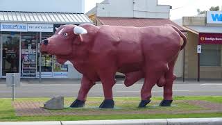
Birchip and Bull in the Wimmera Mallee Birchip is a town in the Mallee. The Sunraysia Highway passes through town and the town is north of Donald. A population of less than one thousand people. The region has gained widespread recognition for its association with the iconic Mallee bull and the rugged Mallee stump. One of the distinctive attractions in Birchip is a meticulously crafted replica of a massive Mallee Bull positioned prominently in the central median of the main street. This artistic representation serves as a testament to the area's rich agricultural heritage and pays homage to the resilience and strength embodied by these magnificent creatures. The presence of this symbolic sculpture not only adds character to the town but also offers visitors a unique opportunity to witness a Mallee Bull up close, showcasing the intricate details and sheer grandeur of this remarkable species. It stands as a striking reminder of the deep-rooted connection between the local community and the land, highlighting the significance of agriculture in shaping the identity of the region. As visitors stroll along the main street, they are greeted by the imposing figure of the Mallee Bull, a powerful symbol that encapsulates the spirit of Birchip and the surrounding countryside. Wycheproof Is in northwestern Victoria. Another small town of a population less than that of Birchip. The name, Wycheproof, is meant to mean 'grass on a hill'. Townspeople claim Mount Wycheproof is the smallest mountain in the world and is not a hill. Located on the fringe of town with about a height of forty-three metres. The town was famous for its yearly 'King of the Mountain' race, in which competitors had to carry a sixty kg wheat bag up the short steep road. The event attracted thousands of spectators. Donald Is a town at the junction of Sunraysia Highway and Borung Highway and has a population more than twice that of Wycheproof. There is riverside signage explaining the story behind the Bullock Head. A large man made structure of a cod fish is on the opposite riverbank. In the quaint town, nestled along the banks of the Richardson River, stands a unique and intriguing landmark known as the Bullock Head. This iconic feature, despite its name, is not a living creature but rather a striking silhouette of a dead tree that has captured the imagination of locals and visitors alike. The Bullock Head is said to bear a remarkable resemblance to the head of a bullock, with its distinctive curved horn, piercing eyes, and flared nostrils. Its weathered bark and twisted branches only add to its mystique, as if frozen in time, telling tales of a bygone era. Over the years, this natural sculpture has become a symbol of the town's rich history and a source of fascination for those who come across it. Traveling through the Wimmera Mallee region makes for an enjoyable journey. Traveldriven DRIVE BIRCHIP-WYCHEPROOF-DONALD THE BIRCHIP MALLEE BULL MALLEE BULL 'BIG RED' DONALD BOLLOCKS HEAD LEGEND OF THE BULLOCK'S HEAD CLAIMED AS WORLD'S SMALLEST MOUNTAIN CARRY YOUR BAG UP THE MOUNTAIN KING OF THE MOUNTAIN MASKED FOR COVID-19 PREV VICTORIA NEXT
- TAKE A REST BREAK AND VIEW THE GIANT KOALA
Dadswells Bridge Is a locality in Victoria, Australia, known for its quaint charm and unique attractions. Situated as a roadside stop along the Western Highway between the bustling towns of Stawell and Horsham. One of the notable landmarks in this area is the Giant Koala, a beloved roadside attraction that never fails to capture the attention of passersby. Visitors can also find a cozy motel and restaurant, providing a convenient stop for those in need of refreshment or a place to rest. The bushfire of February 2024 left the Giant Koala untouched. The Giant Koala Standing at fourteen metres high and built in 1989. The Koala has a small shop inside. There are souvenirs and snacks. The inside may disappoint with its stark interior. At the rear and outside there is an animal enclosure. Chooks etc. It's understood there are no real koalas (2024) on site. Toy koalas may be brought at the inside shop. The Koala is a good rest break area next to the Western Highway. Although the Grampians range can be seen from Dadswells Bridge there is no road access nor is Dadswells Bridge in the National Park. Driving from the Melbourne side, the city of Horsham is about forty km further along the highway. The Western Highway eventually ending in South Australia and the Dukes Highway continuing onto Adelaide. Traveldriven ENTER CLICK/TAP DADSWELLS BRIDGE GOOGLE MAPS DRIVE MELBOURNE DADSWELLS BRIDGE The Giant Koala in Dadswells Bridge. Located along the Western Highway. Melbourne to Adelaide. GIANT KOALA, DADSWELLS BRIDGE CHOOKS & TURKEYS CAN BE VIEWED OUT THE BACK LARGE TURKEY PREV VICTORIA NEXT HOMEPAGE