YOUR NEXT TRAVEL EXPERIENCE
Search Results
249 items found for ""
- SAIL & DRIVE TASMANIA ROADTRIP Devonport Ross Port Arthur
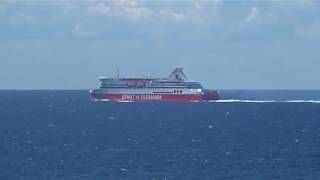
TASMANIA ROADTRIP DAY ONE On this road trip the plan was to roughly follow Highway One in Tasmania from Devonport to Hobart. The highway has a length of just over 300 km and is an inland route. Sail on the Spirit of Tasmania Since 2022 All Victorian Bass Strait sailings depart or arrive in Geelong. Corio Quay Road, North Geelong. One hour driving distance from the Melbourne CBD. I booked a day crossing on the Spirit of Tasmania. Also booked a cabin. Port to port across Bass Strait takes 9 to 11 hours. I was concerned if bad weather would effect the crossing and the movement of on ship vehicles. Cars are parked close together on the ship. The crossing of Bass Strait was all calm seas. So no problems. Easy on/off in the Mustang GT. 1400 passengers and 500 vehicles can be carried. Plenty of comfortable seating. Cooked meals are available to passengers. Devonport is the Spirit of Tasmania disembarkation point in Tasmania. Situated at the mouth of the Mersey River. Devonport has a resident population over twenty-three thousand. Located at Bluff Lookout Devonport is the controversial Spirit of The Sea. The sculpture is a 5 metre tall, 700kg bronze naked statue of Neptune holding a trident in his hands standing on a concrete plinth. Used as a picnic area with scenic sea views. Ross is a historic town in the Midlands of Tasmania. The town is 78 km south of Launceston and 117 km north of Hobart. Ross is a very scenic historic town alongside the Macquarie River. Built by convict labour in the early 1800s. The Macquarie River Bridge is the third oldest still in use in Australia. There are 186 carvings by convict stonemasons on the Ross Bridge. Old elm trees line the main street. A field gun from the Boer War stands in the intersection of the main street. Port Arthur is a town and former convict settlement on the Tasman Peninsula, in Tasmania. Approximately one hundred kilometres southeast of Hobart. Booked a three hour wilderness cruise along the spectacular coastline between Eaglehawk Neck and Port Arthur with Tasman Island Cruises . Using custom built 43 seat capacity boats. The cruise follows along cliffs rising for hundreds of feet along the coastline observing sea life. Normally the sea is choppy but this time glassy calm. Calm only a few times per year. Port Arthur historic convict site is the end point. Traveldriven GOOGLE MAPS ENTER CLICK/TAP SPIRIT OF TASMANIA GEELONG TERMINAL https://www.google.com/maps/place/Spirit+of+Tasmania,+Geelong+Terminal/ DEVONPORT https://www.google.com/maps/place/Devonport+TAS+7310/ ROSS https://www.google.com/maps/place /Ross+TAS PORT ARTHUR https://www.google.com/maps /search/PORT+ARTHUR DEVONPORT FIVE DAY FORECAST DRIVE DEVONPORT TO PORT ARTHUR SPIRIT OF TASMANIA CROSSING BASS STRAIGHT DEVONPORT MALL THE 'JULIE BURGESS' TALL SHIP, DEVONPORT SPIKY BRIDGE BESIDE HIGHWAY TO HOBART UNDER ROSS BRIDGE THE FOX AND HOUNDS HOTEL ON THE ROAD TO PORT ARTHUR BASKING SEALS, TASMAN ISLAND TOUR TASMAN ISLAND CRUISE TOUR ENDPOINT IS IN PORT ARTHUR TASMAN ISLAND TOUR & CRUISE ALONG COAST PREV PAGE NEXT HOMEPAGE
- BRISBANE, RIVER CRUISE NOOSA HEADS & HOME ROAD TRIP AUSTRALIA
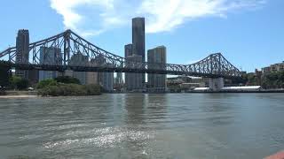
Pacific Highway On this road trip I did not follow the Pacific Highway. The highway is almost 800 km long and runs between Brisbane and Sydney following at times a somewhat twisty coastal route. Brisbane Road Trip Australia If in Brisbane it is a little over a one hour drive to the Gold Coast and one and a half hours to the Sunshine Coast. Both are tourist hot spots with numerous popular surf beaches. Southbank is a popular recreational area in Brisbane. Southbank is on the southern bank of the Brisbane River and easily walked from Brisbane CBD. I prearranged Brisbane accommodation in Spring Hill, near the CBD. Spent one full day in Brisbane. Joined a Southbank Brisbane River tour with River City Cruises to the famous Breakfast Creek Hotel for a mighty steak lunch. A one and a half hour tour aboard MV Neptune. An excellent relaxed way to take in the city sights. Complimentary Morning tea and a beverage on the return trip. $60 including a lunch voucher. Informative commentary. The Breakfast Creek Hotel is probably the most famous hotel in Queensland. Rivalling the Birdsville Hotel. Has weathered many floods. A cold beer and meals are available in the historic bar. Away from the large modern bistro area catering to most visiting patrons. NOOSA HEADS is about one hundred and forty kilometres (85 mi) north of Brisbane. Noosa Heads is the tourist heart of Noosa district, with many restaurants and hotels. The main retail street is Hastings Street, which lies directly behind the seashore. Along Hastings Street it's difficult to get parking. Noosa is the land of roundabouts and suburbs. The Noosa Heads Yacht Club offers a bistro-style restaurant and bar overlooking the Noosa River. Ten minutes drive from Hastings Street. Good for a lunch or dinner alongside the Noosa River. I decided not to continue down the NSW east coast and Pacific Highway as I have travelled the coastal highway a few times before. Through Pacific Highway coastal regional cities such as: Byron Bay Memories of surf life saving carnival's causing many of the town streets to be blocked off by local council. The streets that could be driven were extremely busy to navigate. The city is home to a few famous people tucked away in their coastal retreats. Coffs Harbour and the thirteen metre Big Banana. Now features a large fun park and water park. The first of the big things in Australia. Built 1964. Port Macquarie with it's low high rise looking over the pristine marina and it's boats and the ideal climate. Perhaps enjoying the best year round weather in Australia. Newcastle and it's ocean baths. Nobbys Head views surrounded by water on three sides. Memories of hiring and driving sand buggies in, around and over sand dunes with fighter jets screaming overhead out of Williamstown Air Force Base. On this road trip the return drive was the inland Brisbane expressway to Toowoomba and overnight rest, then onto Goondiwindi on the Queensland border and into Victoria. Ending the three week solo Australia road trip, Victoria to Townsville in Queensland and return. Traveldriven CURRENT BRISBANE FIVE DAY FORECAST BRISBANE GOOGLE MAPS RIVER CITY CRUISES NOOSA HEADS GOOGLE MAPS BRISBANE RIVER CRUISE BRISBANE RIVER & BIG WILLIE SKYSCRAPER BRISBANE CITY STREET LINED WITH PALMS BREAKFAST CREEK HOTEL, BRISBANE BREAKFAST CREEK HOTEL WRITING ON THE WALL THE BREKKY CREEK GANG SIGN BRISBANE RIVER TOUR TO THE BREKKY CREEK PUB BRISBANE WELCOME SIGN SOUTHBANK BRISBANE MALL ENTERTAINER BRISBANE CBD PREV ROADTRIP TOWNSVILLE NEXT PREV QUEENSLAND NEXT HOMEPAGE
- HOTTEST TOWN IN AUSTRALIA Australia Big Righthand Turn Day 9 MARBLE BAR
Great Northern Highway The highway is the longest in Australia with a total length of 3,200 km. This inland highway connects Perth to Wyndham in the far North of Western Australia. The highway route passes through Newman and onto Port Hedland on the coast. Newman is the turn off to the town of Marble Bar. Marble Bar Road continues to the small stop of Nullagine and onto Marble Bar. A road distance of about 300 km. Marble Bar A town in the Pilbara of north-western Western Australia. Extremes of hot weather, with a mean maximum temperature second only to Wyndham, Western Australia. Claimed to be the hottest town in Australia. A town of less than two hundred people in the Pilbara region of north-western Western Australia. A famous Jasper rock outcrop can be seen along the Coongan River near town. Marble Bar Comet Gold Mine has an interesting museum seven km out of town. The most famous building in the town is the Ironclad Hotel built in the 1890s, constructed of corrugated iron. Several large gold nuggets were discovered in the area. Among them the 413 ounce Bobby Dazzler found in the 1890s. I used a White’s gold detector a few km out of town in a dry creek bed. Hot dusty work. No finds. On another much earlier road trip I drove solo Marble Bar to New Norcia on the then unsealed Great Northern Highway. A driving distance of thirteen hundred km of gravel via Newman an iron ore mining town in the Pilbara of several thousand residents. The drive continued down the Great Northern Highway through to Meekatharra and onto New Norcia. This road trip was in a two wheel drive car. Meekatharra Translates as 'place of little water'. Established as a small gold mining town and currently has about one thousand residents. There is accommodation available in the Meekatharra Hotel. Petrol and Diesel fuel is available. New Norcia A monastic town of numerous abbey's a little over an hour's drive from Perth. Abbey tours do not include the monastery as monks live in the building. Traveldriven ENTER CLICK/TAP MARBLE BAR MEEKATHARRA NEW NORCIA GOOGLE MAPS MARBLE BAR FIVE DAY FORECAST TRAVEL DOWN UNDER & DRIVE PORT HEDLAND - MARBLE BAR EARLY DAYS OF MARBLE BAR MARBLE BAR & OUTBACK DEATHS PREV SA/WA/NT NEXT HOMEPAGE
- OUTBACK ROCKETS Australia Big Righthand Turn Day 47 WOOMERA
DAY 47 I needed to dispose of the unused fireworks now highly illegal in Victoria. -find a salt lake Stuart Highway The fully sealed highway runs the full length from Darwin on the coast in the Northern Territory via outback towns of Tennant Creek and Alice Springs and ending in the seaside town of Port Augusta in South Australia. Crossing the continent through the centre of Australia North to South. Woomera A short eight km drive off of the Stuart Highway from the roadside stop of Pimba is the town of Woomera. The town is in fact a ghost town in the Far North region of South Australia. It's appearance is so unlike the vast majority of towns in Australia. Infrastructure but few people. The town buildings and dwellings still look in reasonable condition. The dry climate helps in this regard. Population 7,000 in the 1960s to a few hundred now. Easy to drive the many paved streets as it’s like a modern ghost town. Approximately five hundred kilometres (277 mi) north of Adelaide. "Woomera" also refers to the additional surrounds of the RAAF Woomera Range Complex. A flight testing range covering an area of 122,000 square kilometres (47,000 sq mi). The Woomera range is operated by the Royal Australian Air Force and the town infrastructure still appears to be mothballed as of 2024. Woomera is a Department of Defence owned and operated facility. There are no restrictions for the general public to drive around the large township. There are no privately owned homes in the township. Woomera National Aerospace and Missile Park is interesting. Arrangement was made for accommodation in the old barracks from the Eldo Hotel after a cold drink. Eldo Hotel was the old mess hall. A few local workers were inside taking a quiet break. The only accommodation available is in the old barrack blocks. Corridors are very long and rather narrow. Not unusual for no overnight guests. Very quiet and eerie. Roxby Downs A sealed 78 km road connects to Roxby Downs. Established 1986. The small mining town has a supermarket and accommodation. South Australia Outback Drive To Adelaide I was driving past the occasional small and a few large drying salt lakes scattered along the main Stuart Highway. Considered deposing the remainder of the fireworks I still carried in any roadside salt lake. Possession illegal after Northern Territory Day. A couple of small boxes remaining. Decided against it and safely deposed of soon after arrival in Victoria in the next few days. Left the South Australian Outback behind on approach to Port Augusta. Population greater than 13,000 residents. A city known as the Gateway to the Outback if driving North. The beginning or end of the Stuart Highway depending on direction of travel. The Stuart Highway north from Port Augusta to Darwin is 2,700 km. Not to be confused with the Sturt Highway 959 km in length in NSW to SA. I was driving South and drove a further three hundred km onto Adelaide for overnight motel accommodation. The following day ended the road trip in Victoria. Victoria End of Road Trip I did not use any free camping sites in outback or regional area's. Although fairly common, most appeared not to have any people. At least during dawn to dusk. People tend to keep to themselves after dark in these locations. I decided as a solo traveller I wanted to have an opportunity to chat with fellow traveller's at the end of most days. That's why I used paid accommodation locations with access to convenient onsite amenities. Although this was a solo trip, I enjoyed meeting fellow travellers every day and seeing the incredible diverse country of Australia. Traveldriven ENTER CLICK/TAP WOOMERA GOOGLE MAPS PORT AUGUSTA GOOGLE MAPS DRIVE COOBER PEDY - WOOMERA - PORT AUGUSTA BLAST OFF TO SPACE FIREWORKS BOX ONE OF THE FEW REMAINING ROCKETS OF WOOMERA'S PAST UNDERNEATH AN OUTBACK RAIL LINE LAKE HART SALT ACCESSIBLE FROM HIGHWAY OUTBACK MESSAGE IN DRY SALT CLICK wikipedia Len Beadell of Woomera CLICK ABC news gunbarrel-highway Len Beadell PREV SA/WA/NT NEXT PREV SOUTH AUSTRALIA NEXT HOMEPAGE
- TOSS A COIN TO THE DOG ON THE TUCKERBOX
Hume Freeway & the Dog On the Tuckerbox The Hume Freeway runs the entire inland route from Melbourne in Victoria to Sydney in New South Wales. There are a number of roadside attractions worthy of a stop and a rest break along the freeway. One such attraction is the famous Dog On The Tuckerbox. The Dog Located at Snake Gully. A very famous Australian historical monument and tourist attraction. Five miles (eight kilometres) from Gundagai, New South Wales. A gift shop is on site for Australian souvenirs. The dog statue, perched atop a raised monument, exudes a sense of reverence as it overlooks the tranquil surroundings. Encircled by a shallow pool of glistening water, the statue stands as a symbol of loyalty and companionship. The pool, often adorned with a sprinkling of coins shimmering at its bottom, bears witness to the heartfelt gestures of visitors. Like a ritualistic tradition, tourists partake in the age-old custom of tossing coins into the pool, reminiscent of the whimsical practice observed at wishing wells. Each coin cast into the water carries with it a silent wish, a fleeting hope, or a heartfelt prayer, creating a tapestry of dreams interwoven with the statue's enduring presence. The harmonious blend of tradition, belief, and artistry transforms this serene spot into a sanctuary where the past and present converge in a timeless dance of reverence and wonder. The wayside stop is a location on the Hume Freeway for electric vehicle charging stations. A sign of the changing or should say, charging times. The Dog on the Tuckerbox Tuckerbox is an old word meaning the same as lunchbox. The dog is actually a mongrel dog similar to working dogs the drover's used. A mundane story for a poem but written in such a way as to capture a growing national Australian identity Australians could relate to when it was published in 1857. Conveyed a sentiment of looking out for your mates wellbeing regardless of class or station in life. A notion Australian's have always liked and stood up for. The iconic Australian statue, Dog on the Tuckerbox, holds a significant place in the country's cultural heritage. This beloved sculpture is inspired by the famous poem "Bullocky Bill" penned by the talented poet Bowyang Yorke. The poem itself is a poignant and humorous narrative that captures the essence of outback life in Australia during the early pioneering days. It tells the tale of a resilient bullock driver named Bill and his faithful canine companion who guard a tuckerbox, symbolizing their unwavering determination and loyalty in the face of adversity. Tuckerbox Statue The Dog on the Tuckerbox statue, which is located near Gundagai, New South Wales, serves as a tribute to the enduring spirit of the Australian bushmen and their enduring bond with their loyal four-legged friends. This statue has become a popular tourist attraction and a symbol of national pride, drawing visitors from near and far to admire its craftsmanship and pay homage to the enduring legacy of Bowyang Yorke's evocative poem. The imagery of the dog sitting stoically on the tuckerbox has become ingrained in the collective consciousness of Australians, symbolizing qualities such as loyalty, companionship, and resilience. It stands as a reminder of the hardships faced by early settlers and the importance of camaraderie in overcoming challenges. The Dog on the Tuckerbox continues to evoke a sense of nostalgia and admiration for the pioneers who shaped Australia's rich history, making it a cherished symbol of the country's cultural identity. Traveldriven GUNDAGAI GOOGLE MAPS Drive Albury to the Dog on the Tucker Box THE DOG ON THE TUCKERBOX MONUMENT PREV NSW NEXT PREV CANBERRA ROADTRIP NEXT HOMEPAGE
- FLINDERS RANGES, SOUTH AUSTRALIA END OF ROADTRIP
PARACHILNA Driving past the small settlement of Leigh Creek, a former coal mining town, one approaches Parachilna. Parachilna is sixty-five km south of Leigh Creek and is within a few hundred metres of the roadside turnoff from the sealed, 'The Outback Highway'. Parachilna consists just basically of the well-known Prairie Hotel. Celebrities have been known to frequent the hotel due to feature films made in the general area. Well-heeled patrons come from the cities to experience the outback atmosphere. Fine accommodation and dining is available, and there is an onsite microbrewery with beer on tap. HAWKER Hawker has a population of a few hundred. A very small town in the northern Flinders Ranges between Parachilna and Quorn along 'The Outback Highway' ninety km south from Parachilna. KANYAKA RUINS The ruins located approximately 30 km south of Hawker are a fascinating historical site that offers visitors a glimpse into the past. Accessible by both 4wd and 2wd vehicles, a short turn off The Outback Highway leads to these extensive ruins, making it a convenient stop for travelers exploring the area. The backdrop of brown hills surrounding the site not only enhances its visual appeal but also adds to the sense of mystery and intrigue that shrouds the ancient structures. As you wander through the ruins, you can't help but imagine what life was like for the people who once inhabited this place. This popular wayside stop serves as a reminder of the rich cultural heritage that exists in the Australian Outback, inviting visitors to immerse themselves in the stories of the past and appreciate the enduring legacy of this unique region. QUORN IN THE FLINDERS RANGES Is a Flinders Ranges town. On the edge of the Outback. The first reasonable-sized town south of Birdsville, Queensland 850 km north of Quorn. Quorn has all expected services found in regional towns. The Pichi Richi steam engine and several carriages often leave the Quorn Train Station with passengers for an experience of a bygone era. The steam train departs Quorn Train Station on most days for Port Augusta about 32 km return. The train meets and joins the Afghan Express from Woolshed Flat. Quorn is 335 km distant from Adelaide. Laura and C J Dennis C J Dennis the poet spent his formative years in Laura. In the small South Australian town of Laura's main street stands a monument dedicated to the renowned Australian poet. A literary figure whose influence on Australian culture transcends generations. C J Dennis played a pivotal role in shaping the Australian vernacular by popularizing the unique slang that has become synonymous with the country's identity. His works not only captured the essence of the Australian larrikin spirit but also celebrated the resilience and humor of the everyday person. Fondly referred to as 'the laureate of the larrikin.' C J Dennis's poetry resonated with audiences far and wide, earning him a lasting place in the hearts of Australians. The monument in Laura serves as a tribute to his enduring legacy, reminding visitors of the profound impact he had on the literary landscape of Australia and the preservation of its rich cultural heritage. Laura to Adelaide is about 230 km via Clare in the Barossa Valley wine region. DESERT SKY TOURS The Desert Sky Tour finished in Adelaide, ending nine days and approximately 3,500 km of driving a 2016 Toyota Land Cruiser through the Outback. There were no incidents or problems. Howard, the tour operator and driver, was a very informative and friendly guide. All agreed that the tour was one of those once-in-a-lifetime road trips. BIRDSVILLE TOURS & THE OUTBACK Of course, Desert Sky Tours are not the only Outback small group tour operators. Other operators may be found with small group tours departing from Adelaide or Brisbane. Many use 4WDs or a high clearance bus. A few operate out of Victoria and New South Wales as well. Reputable tour operator's should be found with an affiliation with an established tourist body. There is no need to own a 4WD vehicle, have driving experience, or Outback knowledge to undertake such a road trip. Meals, fuel, accommodation with a proper bed, and a toilet and shower are all included in the reasonable tour price. The providers do this for the traveller. This is great peace of mind in remote areas. Those with mobility issues, travelling alone or as a couple, would find this mode of travel ideal. Towing a large cumbersome van, camping in small tents or swags and a bush toilet doesn't have to be how an Outback road trip is done. Visitors to Australia could easily do such a holiday. Two weeks is plenty of time to allow for flights, etc. Certainly for a nine day Outback adventure. As an Australian, Traveldriven enjoyed the history and the quirky character of the Outback, as did others. People such as Jan, being a solo traveller of the world and of Australia. Thanks to Howard of Desert Sky Tours of Adelaide for his enthusiasm for the Outback, allowing a very few, the opportunity to experience the real Outback. An opportunity made available in safety and comfort. Such a road trip is possible to those many Australians who never venture too far away from the coastal cities. Traveldriven DRIVE MARREE, PARACHILNA HAWKER, QUORN, LAURA PARACHILNA DISUSED TRAIN STATION OPPOSITE PRAIRIE HOTEL PRAIRIE HOTEL PRAIRIE HOTEL EXTERIOR PRAIRIE HOTEL BREWERY NORTHERN, FLINDERS RANGES HAWKER TOWNSHIP SIGNAGE KANYAKA RUINS KANYAKA TOWNSHIP RUINS QUORN TRAIN STATION QUORN STEAM TRAIN LEAVING QUORN STATION QUORN STEAM TRAIN QUORN SHOPFRONT SIGNAGE STATUE OF C.J. DENNIS A LONGTIME RESIDENT OF THE SMALL TOWN OF LAURA PREV PAGE NEXT
- THREDBO SKI VILLAGE & THE MAN FROM SNOWY RIVER
THREDBO SKI VILLAGE Thredbo is a village and ski resort in the Snowy Mountains of New South Wales, Australia. It is about 500 kilometres (310 mi) south of Sydney, accessible by the Alpine Way via the Snowy Mountain towns of Cooma, Berridale, and Jindabyne. Thredbo village is built in the valley of the Thredbo River, also known as the Crackenback River, at the foot of the Ramshead Range. Lake Crackenback Lake Crackenback is seventeen km from Thredbo along the Alpine Way. The lake is very small in area and is about two hundred metre's at it's widest. Many holiday units line the foreshore and the lake is popular for lakeside fishing. Thredbo Thredbo Village has around 4,150 beds, but a permanent population of only about 471 people. When the mountain is fully covered by snow, Thredbo has the longest ski runs in Australia, and this attracts around 700,000 winter visitors annually. In summer, Thredbo is a hiking and summer sport destination, including rock climbing and abseiling, fishing, cross-country cycling and downhill MTB riding and hosts a summer blues music festival. Thredbo is approximately 550ks from Melbourne. Driving from Corryong in Victoria then on to the Victorian/New South Wales border. The fully sealed scenic Alpine Way road begins and passes through Thredbo Village and continues to Jindabyne, the closest town in New South Wales. Kosciuszko Express Chairlift and Merritt's Gondola From Thredbo Village the Kosciuszko Express Chairlift operates 365 days a year. 1.8km in length and rises to a height of 560 metres. The open scenic chairlift takes 15 minutes one way to Eagles Nest restaurant, Australia’s highest restaurant and closest access point to Mount Kosciuszko. From the top of the chairlift there is a popular walking track of 13km return to Mount Kosciuszko's highest point. A relatively flat alpine area. Mount Kosciuszko is the highest mountain on mainland Australia. At a height of 2,228 metres (7,310 feet) from sea level. I visited in summer and did not use the open chairlift. I don’t like heights. The Kosciuszko Express open chairlift has since been supplemented by a eight person capacity enclosed gondola. The Merritt's Gondola takes six minutes from Thredbo Village to arrive at the lower Merritt's Mountain House where dining is available. The Merritt's Gondola is often closed for annual scheduled maintenance during much of October and into November. Open chairlifts after the official closure of the ski season from October onwards may also be closed for maintenance and reopen for the summer months to allow easier walking access to Mount Kosciuszko. Thredbo Alpine Coaster Open year round the Thredbo Alpine Coaster is 1.5 km in length. Speeds of up to 40 km are controllable by passengers as they travel down the twists and turns of the open air railed Coaster. Passes from $16 (2024) The Man From Snowy River Poem " The Man from Snowy River " is a famous poem by Australian bush poet Banjo Paterson. First verse: There was movement at the station, for the word had passed around That the colt from Old Regret had got away, And had joined the wild bush horses - he was worth a thousand pound, So all the cracks had gathered to the fray. All the tried and noted riders from the stations near and far Had mustered at the homestead overnight, For the bushmen love hard riding where the wild bush horses are, And the stock-horse snuffs the battle with delight. Verse thirteen and poem finish: And down by Kosciusko, where the pine-clad ridges raise Their torn and rugged battlements on high, Where the air is clear as crystal, and the white stars fairly blaze At midnight in the cold and frosty sky, And where around the Overflow the reed -beds sweep and sway To the breezes, and the rolling plains are wide, The man from Snowy River is a household word today, And the stockmen tell the story of his ride. Banjo Paterson Early History The Man From Snowy River was penned in the late eighteen hundreds. Australia was finding it's own identity in the world. A group of colonies. England still the highest authority in the land. Australia not yet a Federation of states. Australians looked for inspirations in something they could relate to. Tales from far off foreign shores losing relevancy. Stories and poems from the bush were told and written about. The characters be they real or fictional showed traits Australians admired. Resourcefulness and fairness in a land they were now accustomed too. Be it city or country. Poems were able to be printed and made available to the general public via newspapers of the day. Traveldriven ENTER CLICK/TAP THREDBO GOOGLE MAPS JINDABYNE GOOGLE MAPS THREDBO SKI VILLAGE NSW SKI FIELDS DRIVE CORRYONG TO JINDABYNE THE MAN FROM SNOWY RIVER CORRYONG VICTORIA Lake Crackenback New South Wales MAIN RETAIL STREET OF THREDBO OUTSIDE OF SKI SEASON MERRITTS GONDOLA ENTRY THREDBO THREDBO ALPINE COASTER STEEP CLIMB ON LEFT & DOWNHILL ON RIGHTSIDE LOOKING DOWN ON THREDBO By Toby Hudson - Own work, CC BY-SA 3.0, https://commons.wikimedia.org/w/index.php?crid=9390276 PREV NSW NEXT HOMEPAGE
- STAWELL GOLD TOWN
Stawell Is a small city (town) in the Wimmera region of Victoria about two hundred and twenty-five kilometres west of Melbourne. Population of around six thousand. Stawell is famous for the Stawell Easter Gift, a professional foot race held on grass. The length of which is one hundred and twenty metres or three hundred and ninety feet. Gift events are held on Central Park. The town's cricket and Australian Rules football oval. The gift began in 1878 and is a very prestige event. The Gift Final is broadcast on free to air television nation wide. Stawell is widely known as the gateway to the Grampians National Park which is about twenty km distant. Stawell is one of a few towns in Victoria retaining a large active gold mining operation employing hundreds of workers. 'Big Hill' Lookout The hill that overlooks parts of Stawell offers a breathtaking panoramic view that includes the vast expanse of the Grampian mountain range stretching across the horizon. This vantage point is accessible via one of three roads that wind their way up and down 'Big Hill. One of which leads to a two-kilometre stretch of a well-maintained sealed road that eventually reaches the gold mining operations. Along this road, there is a designated public viewing area where visitors can witness the mining activities up close and appreciate the industrial operations against the backdrop of the natural scenery. At the top of Big Hill, there are three sealed roads that converge at a flat unsealed parking area, providing convenient access to elevated viewpoints that offer views of the town and the majestic Grampians. The strategic location of Big Hill makes it a popular spot for locals and tourists alike to admire the beauty of the surrounding landscape and take in the picturesque sights that unfold before them. Adding to the charm of Big Hill is a pioneer rotunda perched atop the hill, serving as a historical landmark that pays tribute to the area's heritage. Visitors have the opportunity to drive around this rotunda, allowing them to fully appreciate its architectural significance while enjoying the stunning views that it offers from different angles. The combination of natural beauty, historical significance, and modern industrial activities makes Big Hill a unique and memorable destination for anyone looking to immerse themselves in the diverse experiences that this area has to offer. Down On Main Street Stawell's retail street, known as Main Street, holds a unique charm with its intriguing layout. A distinctive feature of Main Street is its unusual kink, a bend that adds character to the town's urban design. This kink is not just a random occurrence but a reflection of the historical development of Stawell as a mining settlement. The street's layout, including its twists and turns, is a testament to its origins and the growth of the town over time. As Main Street meanders through the heart of Stawell, it seamlessly transitions into Upper Main Street, creating a sense of continuity and connection within the town's urban fabric. This transition is not just a change in name but a nod to the evolution of the area and how it has expanded and adapted to meet the needs of its residents. Continuing on from Upper Main Street, Main Street takes a right turn towards Big Hill, leading residents and visitors on a journey through Stawell's past and present. This progression from the retail hub to the scenic route towards Big Hill showcases the diversity of experiences that Stawell has to offer. Overall, Main Street in Stawell is not just a thoroughfare for commerce and traffic but a living history book that tells the story of a town shaped by its mining heritage and the people who have called it home. The kink in Main Street is not just a quirk of urban planning but a reminder of the town's roots and the path it has taken to become the vibrant community it is today. One local popular business is Grampians Ale Works. Local craft beer is brewed onsite. Staffed by friendly owner/operator's. Top end of Main street, and is off a side street named Victoria Place. Offers indoor and outside seating. The Grampians Ale Works is often open on a Friday, Saturday or Sunday afternoon. Traveldriven ENTER CLICK/TAP STAWELL GOOGLE MAPS STAWELL & MAIN STREET THREE WATER FOUNTAINS IN CATO LAKE STAWELL GOLD MINE OBSERVATION AREA BIG HILL LOOKOUT AT DAWN, STAWELL & GRAMPIANS STAWELL TOWN HALL PREV VICTORIA NEXT HOMEPAGE
- CAIRNS & GREEN ISLAND RESORT THE GREAT BARRIER REEF
Cairns Gateway to the Great Barrier Reef A tropical city in far North Queensland between the Coral Sea and the Great Dividing Range which extends as far south as Victoria. Cairns has only two seasons. Tropical wet and dry and the city may be affected by the wet season storms which are prone to develop into cyclones. Special Air Service Display Whilst in Cairns the Australian SAS conducted a display for WW2 veterans and the public on the foreshore. A pair of military Sikorsky Blackhawk helicopters flew low level along the coast to the foreshore and staged a mock rescue of a kidnapped person in a limousine. SAS armed with weapons firing blank rounds rappelled to the ground followed by extrication back to the helicopters. Enactment was very well done. Green Island The island is a coral cay twenty-seven km (17 mi) offshore from Cairns, Queensland within the Great Barrier Reef Marine Park. Green Island is made up of and is surrounded by coral reef. Most tourists are day visitors from Cairns. A forty-five minute ferry ride from Cairns. A luxury resort is the only means of accommodation on the island. The small coral cay island is surrounded by coral reef ideal for snorkeling from the beach. An easy 45 minute rainforest walk encompases the whole island. There is a swimming beach and also a crocodile park attraction. The only island accommodation is provided by Green Island Resort. Arriving on Green Island jetty the silhouette of reef sharks could be seen circling below the boat. Reef sharks are considered fairly harmless if not encroached upon. Traveldriven BARRIER REEF ENTER CLICK/TAP CAIRNS GOOGLE MAPS GREEN ISLAND GOOGLE MAPS IN REALTIME CAIRNS FIVE DAY FORECAST source Wix photo PREV BARRIER REEF NEXT PREV QUEENSLAND NEXT HOMEPAGE
- WALK MAGNETIC ISLAND FORTS OF THE GREAT BARRIER REEF
Magnetic Island of the Great Barrier Reef The island is eight kilometres (5.0 mi) offshore from the city of Townsville, Queensland. Quite mountainous in places. Regarded by many local people as a suburb of Townsville, with greater than two thousand permanent residents many commuting daily to Townsville by ferry. Magnetic Island by passenger & car ferry from Townsville takes approximately 25 minutes. Magnetic Island is locally known as ‘Maggie’. Jet Ski Tour Around Magnetic Island A day trip to this stunning island offers a perfect opportunity to immerse yourself in its natural beauty and rich history. You can embark on a thrilling three-hour jet ski tour around the island, with pleasant stops where you might be lucky enough to spot turtles and other fascinating marine life. For history enthusiasts, exploring the Magnetic Battery World War 2 ruins, also known as 'The Forts,' is a rewarding activity. This free-to-explore area provides a glimpse into the island's past and adds a unique dimension to your visit. Additionally, nature lovers can indulge in a leisurely four-kilometre easy walking track that winds through the island's hilly terrain, adorned with large granite boulders, majestic pines, and pristine sandy beaches. The island boasts a variety of accommodation options to suit every preference, ensuring a comfortable stay for all visitors. It's worth noting that over half of the island is designated as a national park, making it a haven for biodiversity and a part of the southern Great Barrier Reef ecosystem. This status not only preserves the island's natural wonders but also offers visitors a chance to connect with and appreciate the unique flora and fauna that call this island home. Traveldriven ENTER CLICK/TAP MAGNETIC ISLAND GOOGLE MAPS PREV BARRIER REEF NEXT PREV QUEENSLAND NEXT HOMEPAGE
- DAYDREAM ISLAND NAKED MERMAIDS THE GREAT BARRIER REEF
Daydream Island One of many islands within the Whitsunday Islands group in Queensland, Australia. A part of the Great Barrier Reef. Daydream Island is small in size. One km in length and 400m at its widest. The highest point is fifty-one metres above sea level. Daydream Island is in the Whitsundays Island group 5 km off of the Queensland mainland. It's an easy 30 minute ferry transfer from Hamilton Island where daily interstate flights arrive. The island is much smaller and laid back than the highrise of Hamilton Island. All walking tracks and sights can be done within an easy one hour stroll. Naked Mermaids of the Great Barrier Reef Three life-size mermaid statues named Serenity, Aphrodesia, and Infinity, symbolizing mind, body, and spirit respectively, once graced the main foreshore of the island resort. These stunning sculptures were a beloved feature, captivating visitors with their beauty and significance. Serenity exuded a sense of calm and tranquility, while Aphrodesia represented love and passion, and Infinity embodied the eternal connection between the physical and spiritual realms. However, the devastating Cyclone Debbie in 2017 wrought havoc on the island, washing away these iconic statues along with the memories they held. Despite the passage of time, the absence of Serenity, Aphrodesia, and Infinity is keenly felt by both locals and tourists alike. Their disappearance left a void in the landscape, a reminder of the destructive power of nature. In the aftermath of Cyclone Debbie, the island resort underwent a complete renovation to restore its former glory. While the physical damage caused by the cyclone has been repaired, the emotional and symbolic loss of the mermaid statues lingers on. The decision not to replace them speaks to the island's resilience and ability to adapt to change, yet their absence serves as a poignant reminder of the impermanence of beauty and the cycle of creation and destruction that defines the natural world. The island resort has been fully renovated after cyclone Debbie. Updated accommodation and attractions. A new replacement Outdoor Cinema. A new underwater observatory A new expanded Living Reef experience lagoon with more than 100 species of marine fish rays etc. spreads 200m through the resort. Kayak's are available for hire. Kayak around the island. Traveldriven ENTER CLICK/TAP DAYDREAM ISLAND GOOGLE MAPS IN REALTIME DAYDREAM ISLAND MERMAIDS LOST AT SEA Daydream Island Mermaids PREV BARRIER REEF NEXT PREV QUEENSLAND NEXT HOMEPAGE
- GANGSTER DRIVING GOLD COAST STYLE, TRAVEL DOWN UNDER
The Gold Coast is Australia's holiday destination. A large coastal city in Queensland, approximately seventy kilometres south of Brisbane. Local residents are sometimes called Gold Coaster's. The area's population is greater than seven hundred thousand residents. The largest non-capital city in Australia. Surfers Paradise is the hub of the Gold Coast and has world famous surfing beaches and a high-rise beach frontage skyline. All types of accommodation is available. As are theme parks, nightlife, and rainforest hinterland. Travel Down Under to Movie World The Movie World Theme Park offers a captivating experience with its end-of-day Grand Parade, featuring a vibrant procession of beloved movie and cartoon characters. Among the highlights is the appearance of iconic figures like Batman, Cat Woman, Bugs Bunny, Tweety, and Sylvester the Cat, who delight spectators with their lively performances as they gyrate through the parade. The parade also showcases unique vehicles, such as the famous bat car, adding an extra element of excitement to the spectacle. In addition to the Grand Parade, visitors to the park can enjoy a variety of themed enactments throughout the day. One of the popular enactments involves a thrilling portrayal of the infamous 1930s gangsters Bonnie and Clyde as they attempt to rob a city bank. The enactment culminates in a dramatic showdown with the police outside the bank, creating a suspenseful and engaging scene for onlookers. Following this intense performance, a light comedy sketch is presented, providing a humorous and entertaining interlude for the audience. These immersive experiences at Movie World Theme Park not only entertain guests but also transport them into the magical world of movies and cartoons. The attention to detail in the character portrayals, the dynamic parade, and the engaging enactments all contribute to making the park a destination for those seeking a fun and memorable entertainment experience. Traveldriven ENTER CLICK/TAP Gold Coast GOOGLE MAPS Surfers Paradise GOOGLE MAPS CURRENT GOLD COAST FIVE DAY FORECAST GOLD COAST PARADE OF MOVIE CARS PREV AUSTRALIA ICONS NEXT PREV QUEENSLAND NEXT HOMEPAGE