YOUR NEXT TRAVEL EXPERIENCE
Search Results
246 items found for ""
- MEREDITH CAR SHOW & SHINE 2019
Meredith Is a town in Victoria located on the Midland Highway between Ballarat and Geelong. Meredith has a population of under one thousand. The Old Skool Street Cars Geelong has presented the Meredith Car Show for locals and visitors alike. Usually hosted in November at the cricket and football oval. Gold coin donation upon entry. Meredith has also been host to the Meredith Music Festival since 1991. Traveldriven MEREDITH CAR SHOW & SHINE Old signs and merchandise for sale. Nice lemon and black Ford GT right of background on display Beautiful early model white mustang. Silver mags. Left hand drive Open wheeled car. No doors. Elevated fuel tank behind the driver. Large steering wheel. Full size spare tyre and wheel. Rabbit tail (not real) attached to spare wheel Very nice presentable two door coupe. Double headlights Low profile bonnet vent. Great bright cherry red colour Very nice mural on tailgate of stationwagon. Dragon theme Nice clean lines in a gloss white. Two rear radio antenna Left hand drive. Rear down pipes. Custom number plate PREV SHOW & SHINE NEXT HOMEPAGE
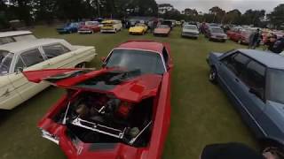
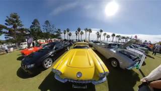
- BALLARAT SPRINGFEST 2023 & 2019 SHOW & SHINE
Ballarat Expanded into a large regional city from when gold was discovered in 1851. Located in the Central Highlands of Victoria, one hundred and fifteen km from Melbourne CBD via the Western Freeway. The city has a population of greater than one hundred thousand residents. In terms of population Ballarat is the third largest inland city in Australia. Often said to be one of the coldest cities in Australia. Lake Wendouree is a man made scenic almost circular shaped lake about two km across. Located within Ballarat city area. Ballarat Attractions Apart from Springfest Show & Shine Sovereign Hill located within Ballarat is an open air tourist park based around the gold era of the 1800s. Over sixty historically correct buildings with themed costumed employees. Officially opened 1970. Eureka Stockade Memorial Park off of Eureka street. Accepted as the site of the miners rebellion of 1884 against the British authoritarian rule and their soldiers. The Eureka Stockade Monument has four 64-pounder large cannon arranged in a circular pattern in parkland. Kryal Castle is a themed medieval castle built off of the Western Freeway twelve km from Ballarat towards Melbourne. Traveldriven ENTER CLICK/TAP BALLARAT GOOGLE MAPS SOVEREIGN HILL KRYAL CASTLE EUREKA STOCKADE MEMORIAL PARK BALLARAT SHOW & GLOW NOVEMBER, 2023 Many hot rods on the green grass Threat of rain and Ford hot rods Many immaculate cars Many supercharged Mustang Shelby official performance report from GM Motorsport in Melton, Victoria Mustang Shelby super snake in the long grass. BALLARAT SPRINGFEST SHOW & GLOW 2023 BALLARAT SPRINGFEST 2019 SHOW & SHINE 2019 Nice flaming paintwork. Open top. Fuel container on front or is it water? Vivid black and red. Front opening windscreen All bright red. Long body. Lowered Spotless interior. Left hand drive. Large matching colour steering wheel Left hand drive. Interior radio. Budweiser gear knob VB gear selector knob. High side mirrors Open wheeler road car DeLorean Back to the Future movie car. Road legal Delorean made in 1981. Gull wing doors. Back to the past 1981 Hot rods on the green grass Two hot rods under a shady tree on firmer ground Overnight rain softened the ground Large fish fins on rear. Left hand drive Bright yellow. Two antenna's on rear PREV SHOW & SHINE NEXT PREV VICTORIA NEXT HOMEPAGE
- CAMPERDOWN SHOW & SHINE
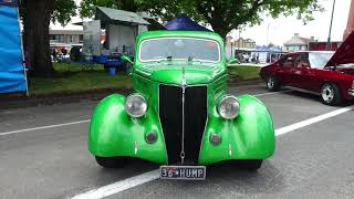
Camperdown Is a rural town in southwestern Victoria. About two hundred kilometres west of Melbourne. Camperdown has a population greater than three thousand. Held on Manifold Street. The main retail street of Camperdown. Particularly like the association of the name manifold to a vehicle exhaust or intake manifold. Like the street was meant to have a car, motorbike or truck down on Manifold Street. Traveldriven ENTER CLICK/TAP CAMPERDOWN GOOGLE MAPS CAMPERDOWN SHOW & SHINE CAMPERDOWN SHOW & SHINE MANIFOLD STREET Unusual stretched limousine ideal for taking it easy. Let someone else do the driving. Full length running board. Like the full size spare mag wheel on the back Hot rod Route 66. Exposed painted engine. Red and yellow nice contrast and the black car body. Suicide doors. Side chrome exhaust for show. Actual exhaust underneath the rear for road legal. A collection of older vehicles. Left of image in need of a paint job. Left unpainted for the effect. Red shiny mag wheels makes you wonder what is under the bonnet Two tone light and dark. Side running board blends in well. Wire spoke wheels suit the vehicle and lowered somewhat Hot rod in immaculate condition Nice curved front bodywork Light blue hot rod. Exposed engine mag wheels and skulls mural down the side. Suicide doors open backwoods on entry Big chrome grille. White roof and red body Down on Manifold Street. Plenty of show cars and onlookers PREV SHOW & SHINE NEXT HOMEPAGE
- DAYLESFORD MOTORFEST SHOW & SHINE
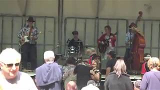
Daylesford Is a mineral water spa town and tourist destination on the fringe of the Great Dividing Range. Forested and green countryside. Many restaurants and art galleries. An alternative lifestyle culture. About one hundred and ten kilometres north-west of Melbourne. Population of under three thousand. The Daylesford Motorfest (Show & Shine) is usually held in February. The 2024 event cancelled for financial reasons. Returning in 2025. The Motorfest is held on the local Australian Rules Football oval. Live music performed by a four piece band. Many stalls and cars on display. Traveldriven. Show & Shine ENTER CLICK/TAP DAYLESFORD GOOGLE MAPS DAYLESFORD MOTORFEST Old immaculate Ford tourer. Nice black and green tone. Full length running board. Mag wheels Hot red coloured hot rod. Owners enjoying a picnic undercover. Hot pink painted car alongside. Queensland number plated Mustang GT in the Victorian Motorfest WRC World Rally Championship? Aftermarket supercharged mustang GT Bonnet is held open and kept raised up by a short length of plywood as seen on the left side of the image. Large spotless chrome grilleand bumper. Detailed artwork above headlights and grille. Nice bonnet emblem Nice two tone colour. Chrome side exhaust. Exhaust is not connected to the engine to comply with regulations. Real exhaust hidden underneath rear of car. Even the dead don't miss out. Funeral Directors hearse. Early model and low mileage. In black of course The Motorfest was a good day out and a picnic day for quite a few people. Old style chairs. Wind up record player. Very nice Oldsmobile. For sale details below. Nice Oldsmobile for sale $20,000. Over one hundred years old. Drives like new? Four out the back quad exhaust. Essendon Australian Rules Football Club number plate and decals. VW tray truck. Paintwork seen better days. Dual front opening windscreen. Lowered Not that practical for driving down the highway. Blue feathered eagle coming into land on the Falcon GT bonnet. Nice bonnet scoop. Driving lights PREV SHOW & SHINE NEXT HOMEPAGE
- OUTBACK CANNONBALL RUN NORTHERN TERRITORY DAY 41
One hundred and thirty km/h is the maximum legal speed on the Stuart Highway to the NT/SA border Present day, some claim unrestricted speed is still allowed. Due to high temperatures, the frequency of roadtrains, no fencing, and roaming wildlife it's likely ill advised to drive above the recommended speeds. Northern Territory Cannonball Run. 1994. Darwin to Alice Springs (Ayers Rock) and return. A legal event. Entry fee of $7500 Total distance driven of about 3200 kilometres. Reportedly 142 individuals entered. Some sharing with co-drivers. Near Alice Springs a Ferrari F40 lost control, hit and killed two officials at a checkpoint, went onto gravel and hit a parked Jeep. Two occupants in the car and two officials killed. After much discussion and delay the event continued and finished in Darwin. First place taken by a Porsche 911 Turbo. The event was never to be run again. Impossible to see how any timed event could ever be held today over similar public roads due to much more awareness and enforcement of safety concerns. Northern Territory Finke Desert Race The two day Finke Desert Race for off road vehicles is probably the best way to race outside of a closed racetrack. Alice Springs to the Finke River community cross country is about two hundred km return as the crow flies. The inaugural race was held in the year 1976. As an interesting observation, the Cannonball Run Memorial site on the Stuart Highway is about 170 km north-west as the crow flies of the overnight rest stage at the Finke Community. Quite close considering the huge area of the Northern Territory. Traveldriven TRY TO AVOID SOLO NIGHT DRIVING DRIVE ALICE SPRINGS - ERIDUNDA - YULARA RESORT (THE ROCK) CANNONBALL RUN CANNONBALL RUN MONUMENT BETWEEN ALICE SPRINGS AND ERLDUNDA ROADHOUSE PREV SA/WA/NT NEXT HOMEPAGE
- GET JAILED IN PERTH, WESTERN AUSTRALIA
Perth The capital of Western Australia. On the Swan River. The river flows to the Indian Ocean. The Swan River is a major feature through the city. Often bordered by parkland between the Causeway Bridge and the Narrows Bridge. The wide river water between the bridges is known as Perth Water. Hire a pushbike. A good way to see the Swan River parkland and city views. Swan Bells Swan Bells, a major tourist drawcard are on the CDB fringe. Riverside Drive. Chimes may be heard ringing out at regular times. A cool Indian Ocean breeze is often felt in the afternoon. Commonly know as, 'The Fremantle Doctor'. Cottesloe Is a beach-side suburb of the city of Perth about half distance between the city centre and Fremantle. Popular beach and place with major surf life saving carnival's. Fremantle About a half hour drive from Perth. A major port city. Many street buskers. The home of Bon Scott of ACDC rock & roll fame. Fremantle Prison tour is recommended. It is said Bon Scott spent a short time there. Rottnest Island of Western Australia Commonly referred to as ‘Rotto’ is 18 km off the coast of Fremantle. Home to the 'Quokka'. A small wallaby. Not dissimilar in appearances to a giant rat. Daily return ferry crossings available. Traveldriven ENTER CLICK/TAP PERTH GOOGLE MAPS SWAN BELLS GOOGLE MAPS FREMANTLE GOOGLE MAPS FREMANTLE PRISON TOURS ROTTNEST ISLAND GOOGLE MAPS PERTH FIVE DAY FORECAST PERTH WATER PADDLESHIP (photo 1990s?) CYCLE RIDE BRIDGE TO BRIDGE ON THE SWAN RIVER COTTESLOE BEACH SURF LIFE SAVING WELL KNOWN FREMANTLE BUSKER, MATTY BLADE RIP OLIVER HILL BUNKER ROTTNEST ISLAND Paddy Hannan and his wheelbarrow in Perth Riverside Drive. Discovered 'The Golden Mile' Kalgoorlie. PREV WESTERN AUSTRALIA NEXT HOMEPAGE
- GET STUCK AT THE MURTOA STICK SHED
Murtoa Stick Shed Historically known as the Number 1 Emergency Grain Store. Originally a large grain store and is now a disused wooden silo in Murtoa made available for visiting tourists. Located beside the railway to service western Victoria's wheatbelt. Some thirty km from Horsham. Mountain Ash Hardwood Timber Pole Construction Five hundred and sixty poles, up to 80-foot-long, went into constructing the cathedral like building. The Murtoa Stick Shed, as it is now known is; 870 feet long or about 265 metres 198 feet wide or about 60 metres 62 feet 10 inches or about 19 metres high at the ridge Covering an area of 170,000 square feet. Full capacity in days gone by was 3.4 million bushels or 95,000 tonnes. Expect to spend twice as long as planned walking the shed. It's much larger inside than you think. Don't get stuck for time. Traveldriven ENTER CLICK/TAP MURTOA STICK SHED GOOGLE MAPS DRIVE MELBOURNE TO MURTOA Murtoa Stick Shed carpark INSIDE THE MURTOA STICK SHED WALKING MURTOA STICK SHED PREV VICTORIA NEXT HOMEPAGE
- GEELONG REVIVAL MOTORING FESTIVAL SHOW & SHINE
Geelong Revival Geelong is a city on Corio Bay Victoria. Geelong is about eighty kilometres south-west of Melbourne. Population is approaching three hundred thousand people. The revival is usually held in November over two days. At North Shore on the Bay. The event has a quarter mile sprint attracting hundreds of vehicles and various show & shine area's. Up to one thousand vehicles may be displayed. Holden HQ Muscle Car A worked Holden HQ stole the show in the quarter mile event. By far the loudest idling car waiting for a turn at the lights. The spectator hill crowd rose to their feet in anticipation of a hot run down the quarter mile. The driver smoked up the rear tyres off the line with a roar of the engine. Tyre smoke bellowed over the watching crowd. All enjoyed the show. One of the strangest vehicle entrants was a lounge couch attached to an engine surrounded by bodywork in the form of a table. A glued on iced coffee bottle and a glued fruit bowl with imitation fruit. Toted as the world's fasted couch, 163 km per hour. Traveldriven ENTER CLICK/TAP GEELONG GOOGLE MAPS RIVER FRONT SHOW & SHINE QUARTER MILE SPRINTS HOLDEN HQ BURNOUT WATERFRONT WALKABOUT GEELONG REVIVAL WALK MAD MAX MAYHEM CAR DRIFTING GEELONG CITY STREETS PREV SHOW & SHINE NEXT PREV VICTORIA NEXT HOMEPAGE
- GET YOUR THRILLS ON ONE TREE HILL, ARARAT JAILHOUSE ROCK & HILL CLIMB
Ararat is a city in south-west Victoria about two hundred kilometres (120 mi) west of Melbourne, on the Western Highway. About one hundred km from Ballarat along the Western Freeway. The freeway converting to highway twenty-five km from the city. Has a population of less than ten thousand residents. Located on the Great Dividing Range. Ararat Jailhouse Rock Festival Held on the weekend after the long weekend in March. The festival begins on the Friday night with a classic car cruise along Barkly Street in Ararat. The main retail street of the town. Followed by a ticketed Rock 'n' Roll Revival show inside the Town Hall. Events and live music are on Saturday and Sunday. One such event is the Saturday morning; Show us your wheels. This event is held in Barkly Street opposite the Town Hall. Open to all types of vehicles and is hosted by Grampians Vintage and Veteran Car Club. One Tree Hill Climb The hill climb is held twice per year. A large hill on the fringe of the town. Height of 1,900 feet above sea level. The track length being 1609 metres in length. Held over a weekend in June and November. The event is generally a round of the Victorian Hill Climb Championship. The Hill Climb is free to watch and many of it's entrants come from interstate. Usually onsite BBQ food is available to purchase. The event is frequented by local car and motoring enthusiasts and organised by the Ararat Car Club Inc. One Tree Hill has a small rotunda at the top and a carpark. The sealed road is rather steep but nice to drive. Not suitable for towed vehicles. Must be thrilling to drive as an entrant in a Hill Climb. Views of Ararat and on the other side of the hill views to the Grampian mountains. Traveldriven DRIVE ONE TREE HILL, ARARAT A hill climb cyclist detailed account of One Tree Hill http://theclimbingcyclist.com/climbs/one-tree-hill-ararat/ ENTER CLICK/TAP ARARAT GOOGLE MAPS DRIVING ARARAT CITY Show Us Your Wheels 2024 JAILHOUSE ROCK MERCHANDISE HOT ROD FLAMES SHOW US YOUR WHEELS MOONSHINE DELIVERIES ARARAT JAILHOUSE ROCK WEEKEND SUMMIT OF ONE TREE HILL, LOOKING OVER ARARAT VIEWS OF THE GRAMPIANS ARE BEHIND CAMERA ONE TREE HILL, HILL CLIMB HILL CLIMB IN CAR CRASH ARARAT HILL CLIMB JUNE 2023 ARARAT HILLCLIMB 2015 ARARAT HILL CLIMB 1993 PREV VICTORIA NEXT HOMEPAGE
- KAKADU NATIONAL PARK & JUMPING CROCS
Kakadu National Park The park is within the Alligator Rivers area of the Northern Territory. Kakadu covers an area almost two hundred kilometres (120 mi) from north/south and over one hundred kilometres (62 mi) from east/west. Darwin to Kakadu park entrance is an easy two and a half hour drive. Distance of 210km. Along the fully sealed Arnhem Highway. On park entry, an entrance fee applies. A Kakadu Yellow Water Cruise is essential. Up to two hours, observing flora and fauna. Crocodiles and birdlife. The township of Jabiru offers tourist facilities and services. The Adelaide River Jumping Crocodile Cruise is a short river tour on the drive to Kakadu and before Jabiru. Cahills Crossing Cahills Crossing in Kakadu National Park is about forty km further from Jabiru and also reached on a sealed road. The crossing has witnessed at least two fatal crocodile attacks. Located on the East Alligator River. One of these, a fisherman knee deep at the waters edge. Another attack killed a male walking the crossing. Widely regarded as the most dangerous river crossing in Australia. Abandoned vehicle's washed into the river can often be seen. Crocodiles gather to eat fish in the murky water. Dozens of large crocs inhabit the immediate area. Safe Crocodile Viewing and Obey the Warning Signs A safe river viewing platform overlooks the East Alligator River and is off to the right side of Cahills road river crossing. This is a safe area to view saltwater crocodiles in the wild outside of an organised tour. Safe for families. It's not uncommon to view multiple numbers of crocodiles from the public viewing platform. Most are in the river. A few are perhaps out of the water on the edge of the crossing. Do not cross the river into Arnhem Land without a permit. Even on the low tide when the crossing may be dry. Still unsafe to do so. Alligator River is a misnomer. Early pioneers thought the crocodiles were alligators and so named the local rivers East and South Alligator. An easy short walk, The Border Store is a short walk near Cahills Crossing viewing platform and is a general store. Driving from Jabiru the fully sealed Kakadu Highway connects with Pine Creek on the Stuart Highway. Pine Creek A short practical hire\drive driving itinerary in the vast distances of the Northern Territory is for a loop drive route Darwin, Kakadu, Pine Creek and return to Darwin. All on sealed roads. Pine Creek is two hundred and twenty-five km from Darwin. To follow the suggested driving loop at least one overnight stay is required to allow an adequate time for tours and see the sights. Two nights even better. Accommodation is available in Jabiru and Pine Creek. For more Kakadu information also read Darwin post. Traveldriven ENTER CLICK/TAP KAKADU/JABIRU GOOGLE MAPS IN REALTIME DRIVE DARWIN TO KAKADU & RETURN JUMPING CROCS ADELAIDE RIVER ADELAIDE RIVER Molly's Kakadu roadtrip. Showcases indigenous rock art which I believe is refreshed regularly by local indigenous people. A traditional practice going back thousands of years to keep living culture alive. Jim Jim Falls may disappoint in the later dry season. Expect dry waterfalls and rough unsealed roads to Jim Jim and Twin Falls. Thankyou to Molly Dixon Youtube for enabling video sharing. Always high quality content by an Australian prepared to go drive and see Australia. Traveldriven UBIRR ROCK ART, KAKADU EASILY ACCESSIBLE BY 2WD SEALED ROAD TO JABIRU TOWN JABIRU TOWN BAKERY PREV AUSTRALIA ICONS NEXT PREV N\TERRITORY NEXT HOMEPAGE
- CAIRNS & GREEN ISLAND RESORT THE GREAT BARRIER REEF
Cairns Gateway to the Great Barrier Reef A tropical city in far North Queensland between the Coral Sea and the Great Dividing Range which extends as far south as Victoria. Has only two seasons. Tropical wet and dry. May be affected by the wet season storms which are prone to develop into cyclones. Special Air Service Display Whilst in Cairns the Australian SAS conducted a display for WW2 veterans and the public on the foreshore. A pair of military Sikorsky Blackhawk helicopters flew low level along the coast to the foreshore and staged a mock rescue of a kidnapped person in a limousine. SAS armed with weapons firing blank rounds rappelled to the ground followed by extrication back to the helicopters. Enactment was very well done. Green Island The island is a coral cay twenty-seven km (17 mi) offshore from Cairns, Queensland within the Great Barrier Reef Marine Park. Green Island is made up of and is surrounded by coral reef. Most tourists are day visitors from Cairns. A forty-five minute ferry ride from Cairns. A luxury resort is the only means of accommodation on the island. The small coral cay island is surrounded by coral reef ideal for snorkeling from the beach. An easy 45 minute rainforest walk encompases the whole island. There is a swimming beach and also a crocodile park attraction. The only island accommodation is provided by Green Island Resort. Arriving on Green Island jetty the silhouette of reef sharks could be seen circling below the boat. Reef sharks are considered fairly harmless if not encroached upon. Traveldriven BARRIER REEF ENTER CLICK/TAP CAIRNS GOOGLE MAPS GREEN ISLAND GOOGLE MAPS IN REALTIME CAIRNS FIVE DAY FORECAST source Wix photo PREV BARRIER REEF NEXT PREV QUEENSLAND NEXT HOMEPAGE
- ESCAPE ERUPTION WHITE ISLAND VOLCANO & ROTORUA
The most dangerous place I have ever been to. White Island White Island Volcano, North Island Active andesite stratovolcano situated forty-eight km (30 mi) from the east coast of the North Island of New Zealand, in the Bay of Plenty. The island covers an area of approximately 325 ha (800 acres), which is just the top of a much larger submerged volcano. White Island is New Zealand's most active cone volcano. Continuous volcanic activity over the past 150,000 years has increased the volcano in size. The nearest mainland towns are Whakatane and Tauranga. Whakatane pronunciation is fuh-kuh-taa-nay Very similar to common curse words. Rotorua, North Island Ride a 900-metre long cableway Gondola with views of steaming geysers and bubbling mud pools on it's way to Skyline amusement park. Slight incline unlike the very steep chairlift in Queenstown. Rotorua is about one hundred km by road to Whakatane and the now discontinued White Island tour boat jetty departure point. White Island Daily Tours Daily conducted tour groups of White Island to view the island's steaming crater were allowed up until a deadly eruption occurred in 2019. An eruption in December 2019 killed 22 people and 25 were left injured on the island. All tourists were on organised adventure tours. Before this some 10,000 tourists visited White Island (Whakaari) each year. Usually by tour boat. I was one such tourist. The most dangerous place I have ever been to. At the time I was fully aware of this. This was in late 2015. Before the tour I did my White Island research. Tour leaflets were scant on the dangers. I discovered steam driven eruptions do occur on occasion with little or no warnings. A few miners in 1914 had been killed by a sudden eruption. The science agency monitoring the island were reluctant to send personal to check equipment on a frequent basis because of risk. Yet tour operations were deemed ok to visit daily. Visitor's required to wear a hard hat, carry a gas mask have sturdy enclosed footwear and wear long trousers. I knew these offered no protection for the body against volatile steam. Distal hissing steam vents and strong sulphur smells protection, maybe. Like many others, perhaps not as aware of steam eruptions as me, I thought one hour on the island is risky but a very brief visit somewhat safe. I decided to go. I made a mental note do it once and never go back. I have experienced a raging bushfire and gale force storms in a sailing boat and even an aviation forced landing. White Island was the most dangerous of all and I knew it. Walking The Volcano All were told not to deviate from the track and walk single file behind the tour leader. Near boiling shallow multi-coloured streams less than a stride wide could be walked over. Told to be careful on uneven ground and avoid ground depressions off the walking track where sulphur gas may settle. Transfer from tender to shore required thought as the water was rough and the crumbling makeshift jetty in disrepair. Heavily rusted old mining structures strewn about. Evidence of previous historical eruptions. Eruption Day An eruption on April 27, 2016, occurred at night without warning when no one was on the island. Tourist visits in 2019 coincided with a large eruption. The eruption occurred on a Monday afternoon. Killing twenty tourists and two tour guides. Although infrequent, eruptions can occur on any day, any time. However, daily visits around the island by boat or aircraft and forbidding setting foot on the island would have been a much better safer option from day one. That said, it's still a risk to go near the island. After all, it's an active unpredictable and deadly volcano. All White Island tourist actively is permanently suspended. Traveldriven ENTER CLICK/TAP WHITE ISLAND VOLCANO GOOGLE MAPS ROTORUA GOOGLE MAPS WHITE ISLAND READY TO BLOW STEAMING WHITE ISLAND VOLCANO SURVIVORS OF WHITE ISLAND AFTER THE VOLCANO ERUPTION ROTORUA PREV PAGE NEXT HOMEPAGE